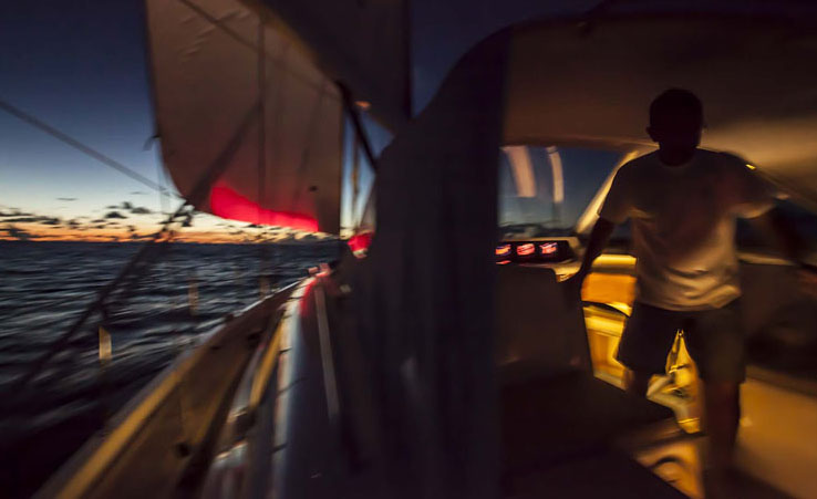
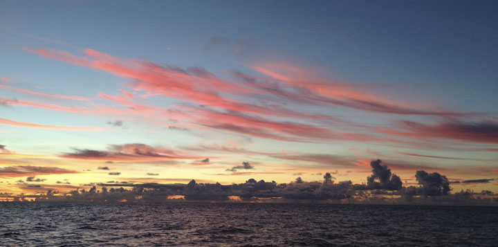
ARC 2013 Last year I was fortunate enough to sail in the ARC regatta. The ARC ( Atlantic Rally for Cruisers ) is a big cruise: 3000 NM between Las Palmas, in Islas Canarias to Santa Lucia in the Caribbean. More than 200 boats joined to the start on November 24th, 2013. Most boats in the ARC are not really racing. People want to have fun and face the challenge of such a long leg. There are many families participating. Of course everybody wants to be fast. But not at cost of putting stress on the boat and crew. Unlike most regattas, in the ARC’s cruising division one can use the motor. Many boats need to run the motor anyway, to charge batteries. But you get penalized for using the motor with 1.5 extra hours per engaged engine hour ( actually the factor is determined by the race committee, based on weather conditions ). Some boats take the race seriously, with professional sailors and top class racing equipment. A boat called Caro did the 3000 NM in 10 days, a new ARC record. I took some of my navigation software to field testing: Navigator, VRTool (for Windows) and Sidekick app (iphone). In the sea, we received race reports every day by email. These mail messages had a list of boats and their positions, in text format. I made a small software module to import the text into Navigator, so that we could follow boat positions in the software chart. One thing I discovered: computer programming on board is the best way to get sea sick. The mess below is what I recorded:
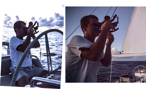
You may download this Navigator ARC13 desktop file here. It is not complete, for I stopped recording the race the day we arrived in Saint Lucia (dec 10th). Time to party ;) Our boat was a nice 62 footer with comfort and modern navigation system. For the amazement of the crew, I brought my good old Davis plastic sextant. And a Samsung Activ diskless Windows 8 notebook, with Navigator installed. Instead of a hard disk, this machine has non-volatile memory and so the battery lasts longer.
Weather routing For weather routing, I started the preparation long before the race, with polar data provided by the boat manufacturer. They provided a single polar chart, in image format, so I had to translate to Navigator format using Navigator Polar Studio. Using common sense, I divided the line into multiple lines, for multiple sails. This is important in order for the program to figure points of sail change. The resultant polar chart for the Oyster 625 can be downloaded here. Navigator weather routing is the same as VRTool’s ( a system used in virtual regattas). It uses NOAA’s GFS wind forecasts. Unfortunately the internet on board was very slow (as most are in the middle of the Atlantic) and the direct grib download from NOAA’s site failed most of the time (timed out). Instead, I choose to use grib files downloaded by ZyGrib. ZyGrib files have extension grb.bz2 ( i.e. are compressed gribs ) and can be imported into Navigator. I took the grib files from the boat navigation computer to my laptop, using a pen drive. This solved the time out problem and also saved in Internet access, for we downloaded each wind forecast only once. UGrib files may also be used.
In Navigator weather routing module use the configuration explained in this wiki page ( Configuration for real world regattas ).
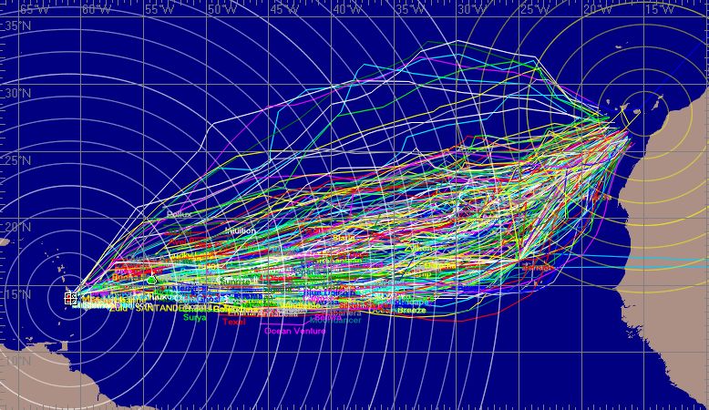
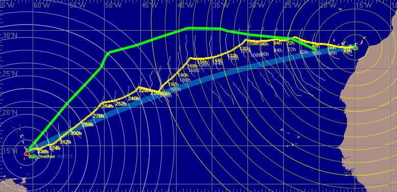
During the rally we run a couple more weather routing optimizations, this time using shorter forecast periods (120 hours). The image below is a Navigator chart showing the best weather routing track (yellow line), calculated before the start of the race (on nov 24th). This was based on a 384 hour wind forecast. Each of the isochrone lines (white curves) represents a 12h period. The green line is Caro’s actual track, the winning boat in the race division. Of course there is not much ground for comparison between the two lines, for the two boats are very different. Our heavier boat did not plane much, so our track was closer to the shortest route (great circle fat blue line).
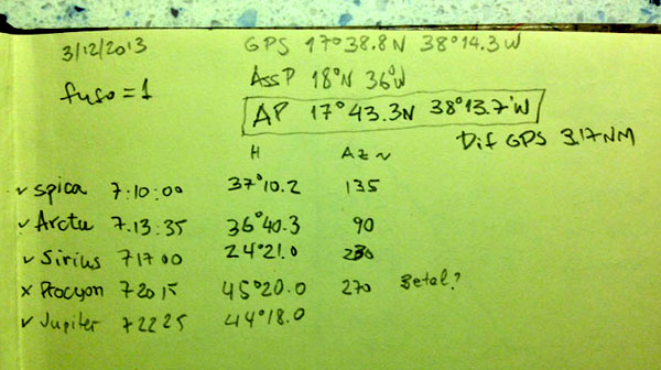
In the dec,3rd observation below, in the morning twilight position I used 4 star sights. I choose to discard Procyon line, because it did not match the other 4 lines. Time zone was 1. The difference from the AP (astronomical position) to GPS position was about 3 NM.
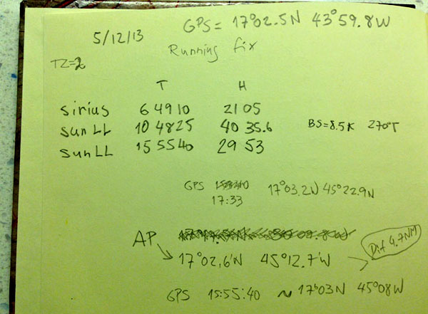
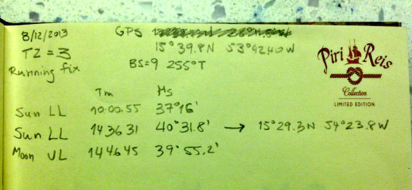
This dec,5th calculation below was a running fix (a position obtained from two or more sights of the same celestial object at different times). Time zone was 2. I took a site of Sirius at 6:49, another of the Sun at 10:48 and yet another for the Sun at 15:55. Considering our boat was sailing at 8.5 knts, direction 270 T, Navigator transported the first lines to the last position time, obtaining a difference of 4.7 NM to the GPS position at that time.
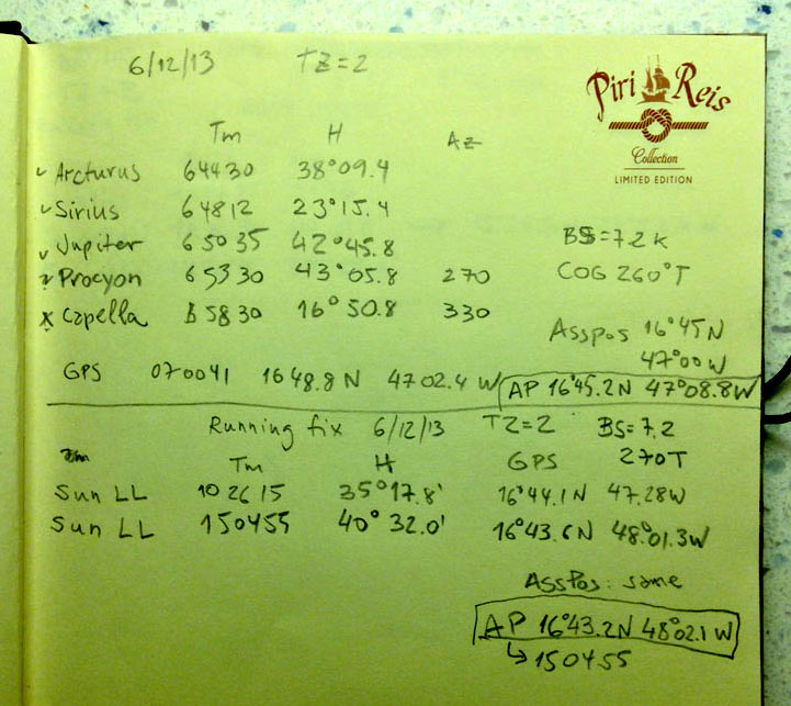
Below is a running fix for the Sun at 10:26 and 15:04 ( Dec 6th) . Boat Speed was 7.2 knts, course 270T. That one was pretty close (about 2 NM) to the GPS reading.
Websites
|

©Copr 92-2012 Omar F. Reis - All rights reserved