VRTool configuration for real world regattas
For virtual regattas, VRTool uses a simplified model of world weather with constant winds for 12 hour periods and across 1 degree rectangles. While this is convenient for game players who don't want to be constantly adjusting their boats, it is not like the real world. In the real world, winds change constantly as you move in space and time.
Wind forecasts are available from NOAA weather model in 6 hour discreet intervals with 1 degree grid resolution. You can think of it as a cubic grid of 3 dimensions: time, latitude and longitude. Forecast data is available for grid nodes. For in-between points it must be interpolated.
VRTool has the necessary machinery to do wind interpolation and model real weather. This tutorial shows the basic parameters to use the program in the real world. It also shows how to connect VRTool and the new mobile app Sidekick for iPhone.
Configuring VRTool properly is a lot work because the program can function in many ways.
The good news is that you only have to do this once.
All config is persisted to the desktop file and is restored when you reload it. Instructions:
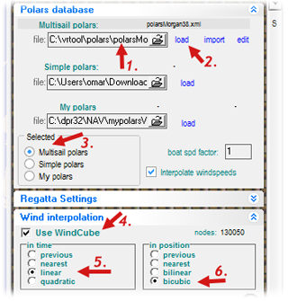 |
If you have just installed VRTool, make sure you configure the Polar Database. This is the performance chart for your particular boat model.
The polar chart is a file with XML extension. You can use VRTool Polar Studio to create and edit your boat polar chart.
Assuming you already have created your polar database:
1. Select the file name (p.e. polarsMorgan38.xml).
2. Click load. The file name should appear above if the file loaded ok.
3. Select [x] Multi sail Polars
In the Wind Interpolation panel, activate wind interpolation by:
4. check [x]Use WindCube. This turns interpolation on.
5. check Linear interpolation in time
6. check Bicubic interpolation in position |
Using NOAA's GFS winds
VRTool can load wind forecasts directly from NOAA's GFS server.
In the settings panel to the left of VRTool main window,
select tab Other and go to Track designer settings
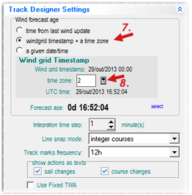 |
7. Select option
[x] Windgrid timestamp + time zone
8. Make sure you have the correct time zone set.
This is important to synchronize the track calculator with the wind forecasts. West longitudes must use positive time zones. East time zones are negative.
In the image to the left, 2 means 2 hours earlier than GMT (i.e. Central Atlantic time).
|
Open the NOAA module by clicking
the  button. button. |
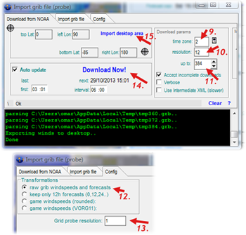 |
9. Set the time zone value (same as above)
10. Set time resolution to 12. This will give 12h forecasts up to 384h. You can also set it to 6 for better detail, but in this case you can only download winds up to 180h.
11. Set time of forecast up to '384' to download all NOAA forecasts (16 days)
12. In the Config tab, set transformations to
[x]raw grid
13. Grid probe resolution to 1 degree
15. Adjust VRTool desktop to include the whole leg area and click import desktop area. This will set the wind download area to the desktop rectangle.
14. Set Auto update parameters if you want the program to update winds automatically. Click Download Now! to start wind downloads.
|
Of course you need satellite internet on board to download forecasts when you are far from cellular networks. The good news is that NOAA grib format is very compact and economic in terms of bandwidth, reducing satellite internet costs.
Weather routing configuration |
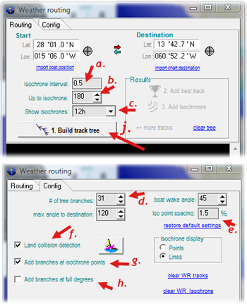 |
Open the Weather routing module by clicking the  button. button.
a. Set isochrone interval to 0.5
b. Set Up to isochrone to 180 or 384. This is the length of the simulation in hours. Cannot be larger than the number of wind forecasts
c. Show isochrones to 12h. This will control which isochrones are shown in the chart.
d. Set number of tree branches to 31
e. Iso point spacing to 1.5
f. Check [x]Land collision detection to avoid islands. (Uncheck for blue water sailing, for faster calculation)
g. check [x]Add branch at isochrone points
h. Uncheck [ ]Add branches at full degrees (this option is for virtual regattas only)
j. Before starting the calculation, make sure you have the Start and Destination points set. Also make sure that you have wind forecasts for the whole area.
Click [Build track tree] to start. This calculation can take several minutes. When finished and successful, you can click buttons [Add best track] and [Add Isochrones] to insert the results in the chart. |
Configuring the VRTool Webserver
VRTool desktop software is designed to be used on the navigation table. Even if you have a convenient Windows notebook or tablet, it is cumbersome to carry to the deck. Desktop energy consumption can also be a problem for long legs. This is the motivation to the development of an app for iPhone that works as a mobile companion to VRTool. It is called VRTool Sidekick (or VSK).
VSK works as a sailing calculator, using the same polar chart used by VRTool. It provides real time monitoring of sailing point. It also uses the iPhone GPS device to log positions that can latter be sent to VRTool desktop, to be included in the boat track.
For more on VSK, check this page
Communication between the PC and iPhone uses VRTool embedded webserver, which must be enabled. VSK can exchange data with VRTool over the Internet or using a local on board wireless network. There are two ways to set up a wireless network in your boat:
1- Use a wireless router - Connect both the PC and the phone to that router.
2- Use Windows ad-hoc network. If you don't have a wireless router on board, the PC itself can function as an access point.
This video shows how to configure the Windows ad hoc hosted network.
In VRTool open the webserver module by clicking the  button.
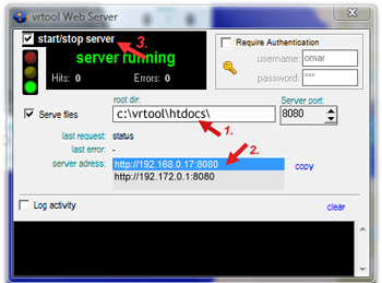 |
1. Set webserver root directory. Note: files in this directory and below can be accessed by the public.
2. The server address list shows all possible webserver addresses (one or more). Your PC can have more than one IP, depending on the number of networks you are connected to. This address will be used to configure VSK in the iPhone.
3. Start the webserver. The semaphone icon shows green light. |
nov13: Om:
©Copr 2008-2012 Omar F. Reis