Celestial navigation with Navigator for iPad
|
This document shows step-by-step examples of celestial navigation calculations with Navigator for iPad. The data used here was collected during the 2013 ARC Regatta (Atlantic Rally for Cruisers). All notes and iPad screenshots are included, so you can practice the calculations and check your results. Five sets of calculations are shown. Navigator for iPad is available in
the AppStore. Click If you are completely new to celestial navigation, note that you need a sextant to actually do it. The app alone will not help you. For a selection of fine instruments, check Celestaire Inc |
 |
Choosing stars
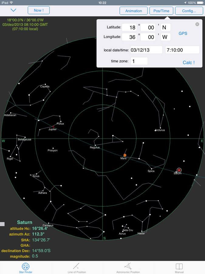
In this first celestial navigation day I had to get acquainted with the stars and planets suitable for observation at morning twilight time. The date was 03/dec/2013. Assumed position was 18°N / 36°W. Time zone +1. Sunrise twilight time was 7:17 local. In order to obtain this information, select the Sun and than click [Object data]. It shows sunrise, sunset, meridian passage and the twilight times.
Tap the Star Finder page. Tap [Pos/Time] button to set star finder position and time. Set approximate position, date, time and time zone ( in this case, time zone was +1 hour. Use positive to West longitudes). Tap [Calc!] button. This will show the sky chart below.
|
Among the stars showing in this chart, some are easy to locate and identificate. Sirius to the West is the brightest star in the sky. Jupiter - a planet - is even brighter. Capella was very prominent in its area. The two brightest stars in Orion are Rigel and Betelgeuse. Rigel is blue, Beteugeuse is red. Spica was in a nice altitude to the East. Procyon was above Orion. The sky was a little cloudy that morning, so I kept waiting for observation opportunities. In the end I had 5 altitudes: Spica, Arcturus, Sirius, Procyon and Jupiter.
|
 Orion, the hunter |
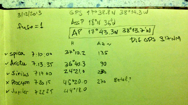
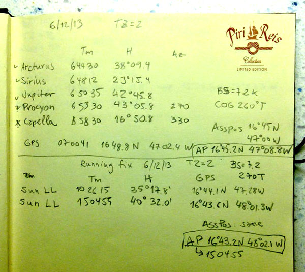
This is my notebook page for 03/12/2013.
Entering altitudes
Before entering the observations, go to the Astronomic
Position page and click [Clear All].
This clears previous observations, as we are about to enter a new set.
Tap the Line of Position page (use buttons in the page foot to navigate between app pages).
First set the Sextant corrections. Click [Sextant
Corrections...] button.
The height of the eye (Dip) was about 3 meters above sea level
for our sailboat.
Use simple refraction formula, for average temperature and pressure.
Set Lower Limb for sun/moon (default).

Click [Sextant Corrections..] button again to close.
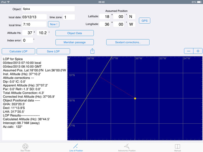
Set assumed position to 18N / 36W.
Somehow the Index error in my old Davis sextant was zero
:)
Enter the first observation: Spica / time
7:10:00 / altitude 37° 10.2'
The altitude is entered in two parts: degrees and minutes. Use dot as
decimal separator for minutes if necessary.
Click [Calculate LOP] when finished typing the altitude.
Below we see the result for this Line of Position (LOP): Intercept
98.7 NM away from the star, with azimuth 122°.
That large intercept value was due to my poor assumed position selection.
Never mind, this doesn't affect the final results.
Tip: After each LOP, click [Save LOP] to save the observation for Astronomical Position calculation.
Second observation: Arcturus / time 7:13:35 / altitude 36° 40.3'

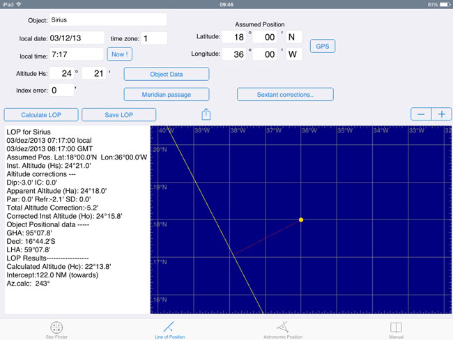
Third observation: Sirius / time 7:17:00 / altitude 24° 21'
Last but not least: Jupiter / time 7:22:25 / altitude 44° 18'

I also took a LOP for Procyon, but end up deleting it, as it seemed misplaced and was almost parallel to Arcturus. Anyway, since I had 4 good lines already, I decided to delete Procyon.
Then I tapped the Astronomical Position page.
Four LOPs saved. I clicked [Calculate Position] and got the result shown below.
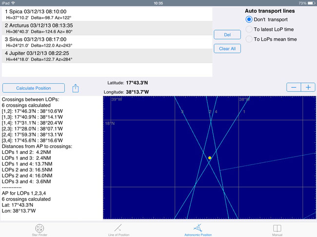
The calculated Astronomical Position was 17°43.3' N / 38°13.7W.
The real (GPS) position was 17°38.8'N 38°14.3'W, an error of about 4.6 NM.
The Running Fix
The next set of observations is from date 05/dec/2013. This one is a Running Fix using Sirius twilight altitude combined with two Sun observations made during that day. The whole observation extended for 9 hours, so the boat movement during that period had to be considered, by transporting the early LOPs to the latest time.
Time zone increased to +2 hours. Assumed position was 17 N / 44 W. Used the same sextant corrections as previous observation.
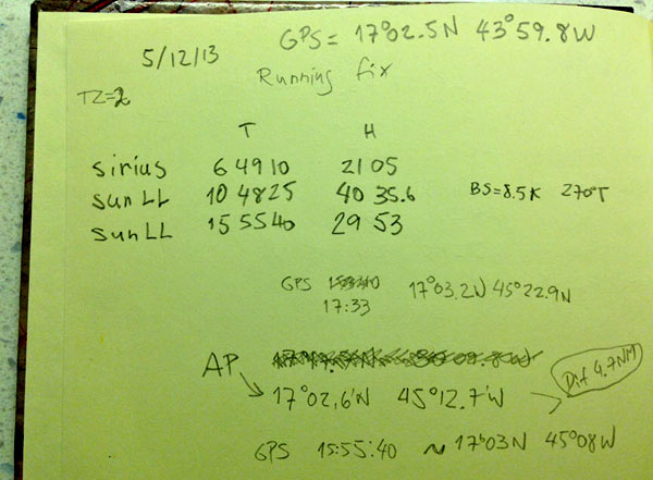
First LOP: Sirius at morning twilight time: 6:49:10 local / altitude 21°05'

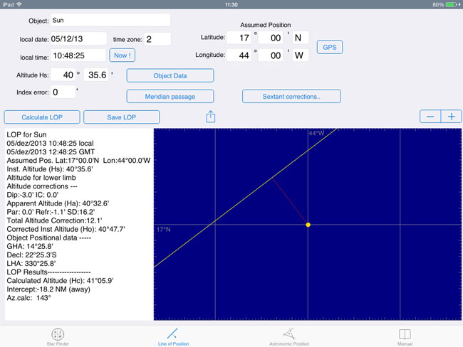
Second LOP. Nice and hot tropical Sun at 10:48:25
local time / altitude 40° 35.6'
This was the altitude of the lower limb of the Sun (the bottom of
it)
Last LOP. Again the Sun , lower limb, almost 4 PM
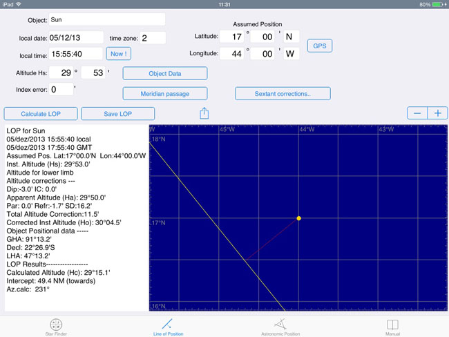
Below is the resulting Astronomical Position calculation.
Note the Auto transport option (top-right below) is set to [x]To latest LOP time. This means that all LOPs are transported to latest time and the calculated Astronomical Position is for 17:55:40 GMT. For the transport to work, I had to inform average boat speed ( 8.5 Knts ) and true course ( 270° ) during the period.
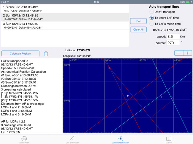
The calculated Astronomical Position was 17°05.8' N / 45°19.8W
at 15:55:14 local.
The real (GPS) position at 15:55:40 was 17°03'N 45°08'W, an error of about
11.6 NM (to the East).
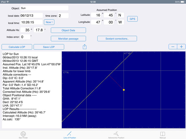
On 06/dec/2013 I did two sets of observations:
The first set was at sunrise twilight (around 6:50 AM local). Time zone was still +2.
Below are the LOPs:

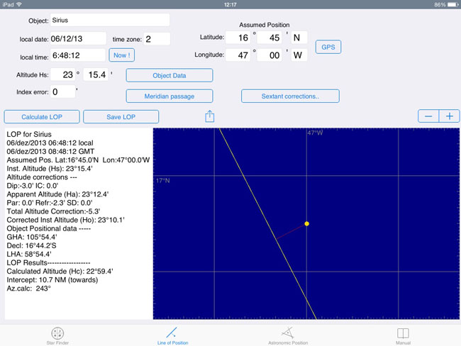

In the end, I choose to exclude Arcturus and Capella from
the final calculation.
Sirius, Procyon and Jupiter gave the result below:
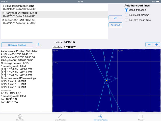
The calculated Astronomical Position was 16°43.1' N / 47°10.3W.
The real (GPS) position at 7:00 was 16°43.8'N 47°08.4'W, an error of about 1.8 NM.
Latter on that same day I made a Running Fix for the Sun with 2 observations.

Again, since this is a running fix, I used auto transport, with our boat sailing at 7.2 knts in direction 270°T.
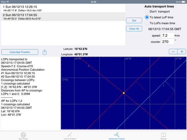
The calculated Astronomical Position was 16°42.6'
N / 48°01.3W at 15:04:55.
The real (GPS) position at 15:04 was 16°43.6'N 48°01.3'W, an error of
about 1.0 NM (to the N).
Best one so far.
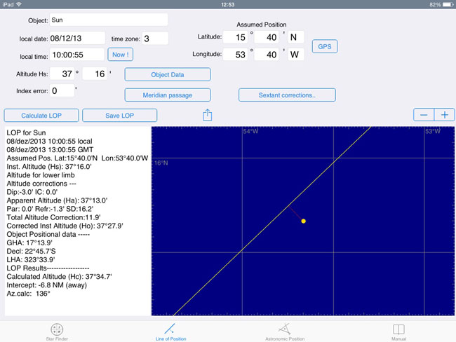
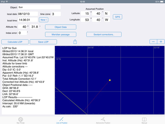
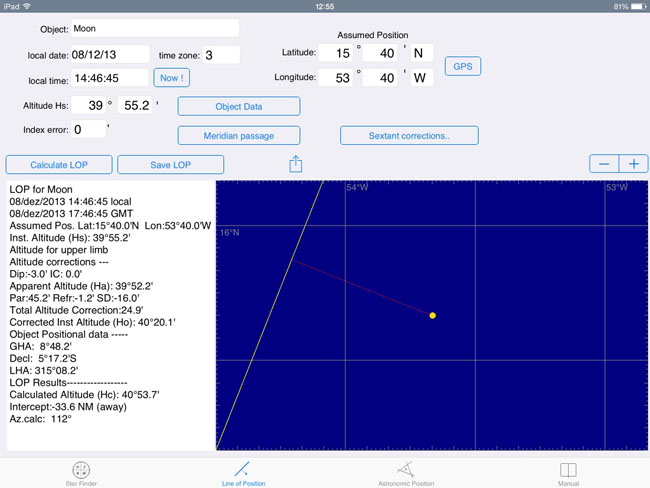
Next set of observation was taken on 08/dec/2013. Another running fix.
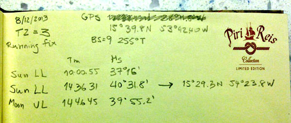
By this time, the time zone had increased to +3 hours. I took two Sun sights and one Moon sight.
Mid morning Sun:
Sun in the afternoon:
Moon sight. Since the Moon disk was incomplete, I choose to read the altitude of the upper limb of the Moon. Make sure to change that in the Sextant Corrections panel before calculating this LOP.
Results:
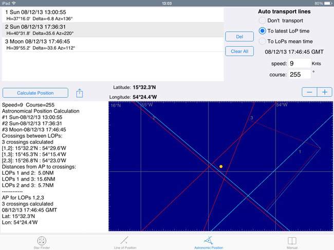
Take a look at this chart. The blue lines are the original LOPs. The red ones are the transported LOPs. Note how the 3 red lines form the position triangle, with the astronomical position on the center. The calculated Astronomical Position was 15°32.3' N / 54°24.4.3W at 14:46:45. The real (GPS) position at 14:36 was 15°29.3'N 54°23.8'W, an error of about 3.0 NM (to the S).
---xxx---
More celestial navigation information - www.tecepe.com.br/nav/
©Copr 2015 Omar F. Reis - All rights reserved