Navigator 4.5 user manual

Table of contents

The access window

>> Chapter 1 - Celestial Navigation

>> Chapter 2 - Star Finder

>> Chapter 3 - Chart Navigation

>> Chapter 4 - ChartMaker


Celestial Navigation links
  1. New to celestial navigation? To understand how it works, go to the Fundamentals page.
  2. Other Navigator screen shot
  3. Navigator software Homepage


The access window

back to the top

Both Navigator and ChartMaker programs have access windows. These are the main menus of these applications. From the access window you choose the module you want to work with.

For Navigator you have the following options (buttons):

  • Chart Navigation
  • Celestial Navigation
  • Star Finder

For ChartMaker:

  • Make vector chart
  • Import chart image

Take some time to read the License Agreement and disclaimer (click "important information"). Closing the access window will terminate the program.


Chapter 1 - Celestial Navigation

The goal of the celestial navigation is to find the astronomical position, the position of the boat. In this section we will see how this can be done with the help of Navigator software. As we have seen in the fundamentals, crossings of two or more Lines of Position, taken for two or more celestial objects, define this position.

Preparing the sky

back to the top

But before you start taking altitudes of celestial objects, you must be able to find them with the sextant. Trying to find a star with the sextant on a rocking boat is not easy The eyepiece has a relatively small angle of view and the sight is twisted by the sextant mirrors.

One technique to find a star is to turn the sextant upside down, point it to the star, and bring the horizon by adjusting the arm.

Better yet is to know the approximate altitudes and azimuths of the stars you are going to observe. This is known as preparing the sky.

The twilights

back to the top

Navigators wake up early. They do so to take advantage of the two times of the day when the sky is in best condition for celestial navigation: the twilights. In the civil twilights - times when the sun is 6° below the horizon - it's dark enough to see the stars and planets, and light enough to see the horizon. This happens before sunrise and after sunset.

The first step of the sky preparation is to determine the time of the twilights.

To calculate the times of twilights do:

  • Select the Sun in the celestial objects listbox.
  • Set the date of the observation. Since you are probably going to prepare the sun in the night before, set the date to the following day.
  • Set the assumed position (Latitude and Longitude). It's the position you think you are going to be in the time of the observations.
  • Select the tab "Other calculations"
  • Press "Object data" button.

The last two lines show the time of twilights. Like this:

dawn civil twilight: 9:13  GMT
Set  civil twilight: 20:46  GMT

 
Selecting stars and planets

back to the top

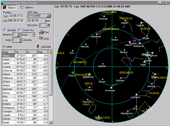
Now that we know the twilight times, you can select the celestial objects you are going to observe. At any time, Navigator gives you more than 33 celestial objects to choose from. Of course you will only need 4 or 5. To select stars and planets you will observe, follow these guidelines:

  • Select stars and planets that you are most familiar with.
  • Select the brighter objects. Planets are easier to spot, because they are very bright. Some stars are also very bright and easy to find. Some constellations have distinct look and are easier to locate.
  • Select objects with altitudes between 30° and 60°. Less than that you result in greater atmospheric refraction error, which is not easy to correct (because it depends changing on atmospheric conditions). And altitudes higher than 60° are more difficult to measure.
  • Do not select stars that have similar azimuths or that are in opposition. The resultant Lines of Position will be nearly parallel, which is undesirable.

To prepare the sky do:

  • Set date and twilight time of your next observation.
  • Set the assumed position (Latitude and Longitude).
  • Select the tab "Visible stars".
  • Press the "Calculate" button.

Now choose the stars in the spreadsheet or chart. To see the name of star in the chart, click the mouse over it. The name will show in a "hint label". Or select the star in the spreadsheet. A circle will show around the correspondent star in the chart.

If a printer is available, Navigator can print a convenient sky preparation (one page), with visible objects table and polar chart.

Input tip: When unsure about how to enter a value (date/time format, number format or number unit), place the mouse cursor over the input box. A hint will show with the field name, input format and/or example.


Taking altitudes

back to the top

Now lets take the actual measurements. Take the following items to the deck of the boat:
1) Sextant.
2) Watch.
3) Pencil.
4) Paper with your sky preparation. Attach the paper to a board, so it's easy to take notes and your work will not be carried away by the wind.

Try to establish a routine to handle these items. You will be observing two numbers (altitude and time) at once, possibly on a rocking boat, so don't let these items make things difficult in the critical time. You might want to use preprinted tables to organize your data, like the one below. Save them as the documentation of your work.


Date: twilight time: assumed lat: assumed lon:
index error: watch error: time zone: Obs:
celestial object
sky preparation
observations
results
LOP
Name
Altitude
Az
Time
Hi
Delta
Dir
Az
1                
2                
3                
4                
5                
6                
Astronomical position for ____ LOPs Lat: Lon:


-> Click here to open this table in a new window, to print some copies

When taking an observation, set your sextant to the expected altitude and point it to the expected azimuth (from your "preparation"), using a hand compass. The celestial body will probably show in your view.

  • Adjust the sextant to the correct instrumental altitude. Write name, time and altitude of the observed celestial object.
    1. It's good practice to adjust the sextant micrometer drum always in the same direction. For example, put the star below the horizon and then bring it up by turning the drum in the same direction in all observations. If you go past, repeat the operation from the start. Do the same for the Index Error measurement. The sextant will give different readings, depending on the direction you adjust the drum. Using the same direction for both altitudes and index error measurements cancels this problem.
    2. After adjusting the sextant's drum, read the watch first, because it's changing fast. Write the time. Then write the sextant altitude.

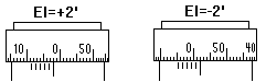
Before and after taking altitudes, measure the Index Error:

  • Set the altitude to 0°00' and point to the horizon.
  • Adjust the drum until both sides of the horizon are level.
  • Read the Index Error and write it.

Back to the navigation table, run Navigator.

  • Enter the index error.
  • Enter Height of the eye (Dip). In version 3.0+, you can choose the Dip units (meters, feet or minutes) .
  • Enter watch error, in seconds. See keeping the time for more information on time keeping methods.

Note on the index error: In versions prior to 2.5, the IE was typed with the plus signal when the index error was inside the drum scale. This number was then subtracted from sextant reading by the program.

Many users complained that this input convention was against the common practice in celestial navigation. They were used to work with the Index Correction (IC), with signal - when the IE was inside the arc scale.

After many messages, I agreed. Starting with version 2.5 and up, I changed this. So, if you are upgrading, make sure you use the correct input convention, as illustrated on the right.


Navigator 2.5 and up
Type IC = -2 type IC = +2

Old versions (navigator 2.0 and prior)
Type +2 type -2


Clear all previous LOPs:

  • Select the tab "Astronomical Position".
  • Press the toilet button, to clear all LOPs.
  • Now select the "Line of Position" tab.
  • Set the assumed position (Latitude and Longitude).

Now enter the measurements, one by one. For each celestial object, do:

  • Select the celestial object from the listbox.
  • Enter time of the observation.
    1. You can use local time or GMT time edit boxes. In this case, automatic conversion to GMT is done.
    2. If using local time, make sure the time zone and watch error edit boxes are correctly set.
  • Enter altitude of the celestial body.
  • Press the "Calculate" button.

The result will be something like this:

LOP for Sun
05/04/2001 13:43:54 GMT
Ass.Pos. Lat:23°40.0'S  Lon:40°30.0'W
Inst. Altitude: 56°24.5' 
Altitude of lower limb
Altitude corrections ------------
Par: 0.0'  Refr:-0.6'  SD:16.0'
Dip:-3.1'  IE:-2.0'
Total Altitude Correction:10.3'
Corrected Inst Altitude: 56°34.8' 
Object Positional data -----
LHA: 344°48.9' 
GHA: 25°18.9' 
Decl:  6°13.8'N
LOP Results------------------
Calculated Altitude: 56°37.8' 
Intercept: -3.0 NM (away)
Az.calc:   28°


The two last lines have the results (Delta and Azimuth).

If you feel the result is consistent with the expected , press the button "Save LOP". This will save this Line of Position for the calculation of the Astronomical Position (Fix), which will be done after you calculate all LOPs.

After calculating and saving all LOPs, go for the astronomical position calculation:

  • Select the tab "Astronomical Position". The LOPs you have just saved will be in the spreadsheet.
  • Press the "Calculate" button, to calculate the astronomical position. Your astronomical position will show. Please note that, in order to calculate the astronomical position, you have to have two or more LOPs. Having more lines is advisable, because errors in one observation will show more easily. A good number is 4 LOPs. Also, as we will see, sometimes we are going to discard some of them.
Refining your calculations

back to the top

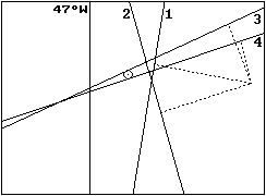
To achieve good results in celestial navigation, you need to be methodic. As you can see, there are many steps, and a mistake in one of them will only show in the end, if at all.

Enumerate the tasks you are doing - or are going to do - and read the measurements loud before taking note (navigators are said to speak to themselves). Make your notes in an organized table, one row for each celestial object. In the header of the table, write date, assumed position, time of twilight and index error. Have the sky preparation ready before going to the deck.

But even with all the care, some errors will eventually show. Wrong time or altitude (the so called 60 mile error). Bad star identification. Even wrong date. The important thing is to detect mistakes, and drop the LOPs with problem.

Having good dead reckoning navigation helps a lot. It's also a good idea to take a look in the chart showing the Lines of Position. If one of them seems out of the flock, you may deselect it and recalculate de position. This is why it's good to have more lines.

Another problem is to have two or more LOPs that are nearly parallel. They will probably cross very far from the correct position, even if they are close together. Navigator accounts for this situation by giving a small weight to crossings forming small angles. But it's better to deselect one of them and recalculate the position.


LOPs 3 and 4 nearly parallel. Select only one of them.


In the figure above, we can see that LOP 3 and 4 are nearly parallel. Deselecting one of them would improve the resulting calculated astronomical position.

Observing the Sun

During the day, you can observe the Sun and the Moon. If you can see both at the same time, and they are in suitable positions for observation, you can calculate a fix, using the two lines of position. The procedure is the same described above for stars and planets.

The only difference is that the Sun and Moon have appreciable diameters (about 32'). When measuring the altitude of Sun and Moon, align the lowest part of the body with the horizon. This is known as the lower limb. Navigator will correct for the semi-diameter automatically.


Sextant image

You can also use the upper limb. In this case, uncheck the "Use lower limb" checkbox.


Running fix

back to the top

The altitude of the same celestial object in two different times may be used to find the position. For example, you can take two Lines of Position for the Sun, one in the morning and one in the afternoon. Because your boat is moving, you will have to transport the first line to the second line time. The position obtained with this method is called running fix.

Navigator (version 4.0 and up) can be set to transport LOPs automatically, when calculating the astronomical position. This is done by moving the assumed position. The LOPs chart shows the original LOP (blue) and the transported (red).

Take a look at the Auto Transport frame n the image to the left. This is where LOP transport is setup.

  • Choose one of the following transport modes.
    • Don't transport
    • To latest LOP time
    • To LOPs mean time
    • To Selected Time (i.e. specified in the top time frame)

  • Click 'Edit boat C&S' (course and speed) and update boat movement data.
  • Click 'Calculate' to calculate the astronomical position.


Simple meridian passage (noon sight)

back to the top

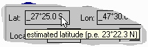
When the Sun crosses our meridian, its azimuth is either 0° or 180° (North or South). This means that a Line of Position (LOP) for the Sun, taken at this time, will have constant latitude. This event is called transit or meridian passage. For the Sun, it happens around local noon (+/- 20 minutes).

The navigator can take advantage of this event to check the latitude. The longitude can also be calculated, although with smaller precision.

This is what you must do:

  • Start taking observations of the Sun (time and altitude) about 25 minutes before the expected transit time. In Navigator, select the Sun and use the command Object Data to estimate the transit time for the Sun in your assumed position. Take a couple altitude observations (p.e. 5 minutes apart) until 15 minutes before transit.

  • At transit time, observe the highest altitude the Sun reaches. This is known as culmination altitude. It´s easy to measure, since the Sun will appear to hang with constant altitude while passing your meridian. After that, it will start to go down.

  • Write the culmination (maximum) altitude.

  • Keep checking the altitude until the Sun, now going down, is at the same altitude it was in one of the observations made before transit. The time of transit is the average of two times with equal altitudes (before and after transit).

    For example, if you measured 61°32' at 11:45:30 and 61°32' at 12:10:10, the time of transit is (11:45:30+12:10:10)/2 or 11:57:50. The altitude value is the maximum altitude you observed (near transit time).

  • Enter the transit time (the average you calculated) and the culmination altitude in Navigator. Select the tab "Other calculations" and click the "Simple Sun Meridian Passage" button. Program will give your position.

It's important to understand that the Latitude result is related to the maximum altitude the Sun reaches, and the Longitude to the exact time of the passage. So, the latitude can be safely determined even if you don´t have a reliable watch.

Better meridian passage calculation

back to the top

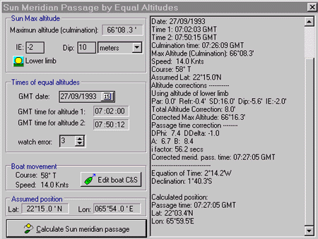
While the method just described is OK, is does not account for two factors: Sun declination change and boat position change. These two factors can affect the longitude result.

The Sun declination is always changing. It changes faster on equinoxes (spring and fall) and slower in solstices (summer and winter). So, the Sun 30 minutes after the passage is not in the same place (in the celestial sphere) as 30 minutes before the passage.

The boat movement during this period can also be of significance, particularly if the boat is fast and is moving along the meridian.

These two changes affect the actual meridian passage time. In this case, the average time between two equal altitude observations (before and after transit) is not the meridian passage time, but rather the culmination time. A correction must be applied to find the right passage time (and the Longitude).

To perform this calculation on the Navigator, select the tab "Other calculations" and click the "Sun Meridian Passage by Equal Altitudes" button. The form below will show.

Enter maximum altitude (w/o corrections), IE, Dip, GMT date, GMT time of altitude 1 (before transit, w/o watch correction), GMT time of altitude 2 (after transit), watch error, boat speed, boat course and assumed position. The GMT times 1 and 2 are the ones of equal altitude observations (the actual value of the altitude is not used in the calculation, but remember to write it down, because you will have to use the sextant to measure the maximum altitude between the two observations).

The correction i is the difference, in seconds, between the culmination time and the transit time. It can be as much as a minute, or 15' in the longitude.

Please note that there are a couple conditions to use this method:

  1. Sun altitude must be at least 65°.
  2. The Sun's azimuth must be at least +/-20° on equal altitude observations.
  3. The equal altitude observations must be up to 40 minutes - before and after - transit time.

This method is particularly useful near the Equator.

Tip: If there are clouds in the sky, it's recommended that you take several observations before transit. If you take only one, the Sun may become covered in the critical time after transit. By having many observations, you increase the chance of having one usable observation pair.


Source: Navegação Astronômica e derrotas

Artificial Horizon

back to the top

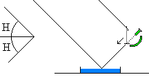
If you live in a city far from the sea, you can't take altitudes of celestial bodies with a marine sextant, because you can't see the sea horizon. One way to work around this problem is to use an artificial horizon. The artificial horizon can easily be made with a plate filled with liquid. Water will do, but oil is better. The surface of a pool can also be used, if there is no wind or waves (the water surface must be completely flat).

To take the altitude with the artificial horizon, point the sextant towards the artificial horizon and make reflected image of the celestial body coincide with the direct image. The angle you read is twice the altitude of the body, as illustrated in the figure below.

Also read the index error.

Navigator automatically corrects for the use of artificial horizons:

  • The program divides instrumental altitude by two. Enter sextant reading directly.
  • The Dip and semi-diameter corrections are set to zero.
  • The index error is also divided by two.
Printing Nautical Almanac Pages

back to the top

Navigator (registered version 2.5 or latter) has a Nautical Almanac page generator/printer. These pages are not exactly the same as real almanac pages, but they contain most of the information needed to do celestial calculations in the traditional way, without the computer.

Navigator generates the so-called "daily pages" (the ones with 3-day celestial data for planets, stars, Sun, Aries and Moon). The yellow ("increments") pages are not generated because they don't change from year to year. You can use the yellow pages of an old almanac or do the interpolations with a pocket calculator.

I choose to make the Navigator daily pages as similar as possible to actual almanac pages. But there are differences:

  • Did not include the latitude dependent tables (Twilights, Sunrise, Moonrise, Sunset, Moonset).
  • Did not include the Aries meridian passage time. This number is used to calculate the meridian passage of stars, and is seldom used.
  • Did not include the Sun's Equation of Time and meridian passage table. You may use an old almanac for the Sun's meridian passage calculations, as these tables are almost unchanged from year to year. Just use the table of the same day.
  • Did not include the Moon's meridian passage and age table.
  • Did not include the planets' SHA and meridian passage table.
  • Added three stars not included in most Nautical Almanacs

I plan to include some of these numbers in future versions. Feedback from users about what features are most important is welcome.

If you compare the Navigator's almanac pages with nautical almanac pages, you will note small differences in the numbers. These are caused by different celestial calculation methods and should not be bigger than 0.5'. This error is small when compared with other imprecisions that affect celestial navigation, and will not impact your position significantly.

Printing the almanac pages

To print almanac daily pages, do:

  1. Go to the celestial navigation window.
  2. Select the "Other calculations" tab.
  3. Press the "almanac pages" button. The "Almanac Pages" window will show.
  4. Set the initial date for the 3-day page.
  5. Select "Aries and planets" (left side page).
  6. Press "Build page" and "Print".
  7. Select "Sun, Moon and Stars" (right side page).
  8. Press "Build page" and "Print".
  9. Click in the "Arrow" button to advance 3 days and repeat operations from step 5). Proceed until you have printed all the pages for the desired period.

In order to print your almanac pages, you have to use a non-proportional font (a font with fixed pitch). The default font is Courier New, size 7. Pages printed with this font will use a single sheet of paper (size A4). I know this is a small font, but using a larger one will result in two paper sheets for each page. You may experiment with other non-proportional fonts. True type fonts are better, because they can be resized to any small size.

Check the online web service, open to the public. Click to visit this service.


Chapter 2 - Star Finder

Navigator Star Finder (version 3.0+) was completely redesigned. To accommodate the new set of features, this chart of the visible sky was moved to its own window (in previous versions, it was part of the celestial navigation window).


The new features include:

  • Constellation lines and names make it easy to identify constellations and celestial objects.
  • Ecliptic plot shows the path of the Sun, Moon and planets.
  • Celestial objects grid can be sorted by columns (ascending and descending order) clicking the column header.
  • The spreadsheet now includes object magnitudes (note: many celestial objects have changing magnitudes. These values are fixed, to be used only as rough estimate).
  • Mouse cursor shows altitude and declination when moving. When pointing an object, its name, altitude, azimuth, declination and right ascension are shown. Values cursor is transparent, so you don't loose the big picture.
  • Prints the object list and chart. The printed chart uses the printer higher resolution.
  • Time zone is now imported from the operating system, accounting for Day Light Savings time.
  • Sky background color indicates the light conditions (day=blue, night=black and twilight=navy).

  • Windows® Clipboard support allows to cut-and-paste the chart to other applications.

  • Overhead view option, so you can look up to the sky and the chart simultaneously. In this representation, E and W are flipped and the chart is to be viewed upside down
    (see figure to the left)


  • Options tab allows easy and interactive chart setup (see figure to the left).
  • Boat course plot, to easy printed chart orientation.
  • Star finder chart and table now print in the same sheet of paper, much more convenient.

Using the Star Finder is easy:

  1. Set your position (Lat/Lon)
  2. Set the GMT date and time. If you opened the star finder by clicking the button in the celestial navigation window, these values are automatically set.
  3. Set the boat course (optional)
  4. Click the Calculate button

You can also animate the sky, specifying time increments and calculation frequency. This can produce very interesting animations, like how the sky changes from hour to hour, day to day and year to year.

And it can also be set to show the current sky.


Chapter 3 - Chart Navigation

The Navigator chart module is relatively new (started in version 2.5), but has received important additions in version 4.0. It's now much more useful with the addition of raster chart capabilities.

Instead of supporting the existing electronic chart formats, I choose to provide a set of tools to allow the user to import existing paper chart images into the program. This 'do-it yourself' approach gives the user maximum flexibility.

All Navigator files are in text format and their structures are easy to understand, to allow integration with other applications and Internet file sharing. The table below enumerates the Navigator data file types.

File extension Description
.CHT Navigator vector chart file
.NAV Navigator desktop file
.CID Navigator chart image description (raster image)


Vector and raster charts

back to the top

The Navigator chart engine can show two kinds of charts: vector charts and raster charts.

Vector charts - In this type of chart, islands, continents, routes and tracks are represented by polygons and lines, defined by a collection of points (Lat/Lon pairs). This kind of chart can be easily zoomed in and out, and is very fast to render. Navigator uses its own vector chart file format. No other chart file format is supported at this time. These files can be produced, from scanned charts, using the ChartMaker program.

Raster charts - These charts are images (normally scans of paper charts). Navigator can use raster images in formats JPG, GIF or BMP. These are popular file formats in the Internet, and many charts can be found for download over the Net.

All raster chart image files must first be imported - using ChartMaker program - before they can be used in the Navigator. This step is necessary to describe the chart image scale (i.e. how pixels in the image map to the real world).

Both vector and raster charts can be produced or imported using the ChartMaker program, which is described in the next chapter.

Using raster chart images

back to the top

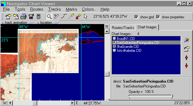
In the image above you can see two raster chart images visible in a desktop, on a zoom animation. Before opening it in the Navigator, a raster chart image it must be imported. This is done only once for each image, with the ChartMaker program. The step creates a .CID file that is associated with the chart image (GIF or JPG). This file contains:

- Name of the associated image file (GIF, JPG or BMP)
- File description
- Reference points (which define how the image pixels map to the real world)
- Image MD5 digital signature (to prevent accidental changes in the chart image)
- Chart limits (outside rectangle)

Once the CID file is created, it can be added to a desktop. Click the chart image open button and select the CID file. Many chart images can be added to a given desktop. Images can be either visible or not. To play with chart visibility, use the small checkbox in the chart images listbox.

Tip: Since images are large in size, making many visible at the same time would consume a lot of memory. Making only the charts you need visible reduces the amount of memory used by the program. A memory of at least 32MB is recommended to use raster charts.

The image resampling process also consumes a lot of CPU power. To reduce the bumpy behavior while zooming or scrolling, these calculations are implemented in different threads of program execution . That's why it takes some time for the raster charts to show after you zoom or scroll.

You can also play with raster image opacities, making them partially transparent. This allows you to see how two charts overlap each other or compare them with the vector chart underneath.

Tip: Partially opaque (i.e. transparent) chart images consume CPU power - a 100% opaque chart will display a lot faster.


The chart images rendering order can also be changed, using the up and down arrow buttons in the right. The rendering order is:


1- Background (sea color)
2- Vector chart polygons
3- Chart images (top-down order in the listbox)
4- Routes, tracks and marks

Tip: To transfer a CID file to another computer (or to share it over the Internet) , you also need to transfer the associated image file (GIF or JPG). Since the CID file contains the image file digital signature, there is no risk of accidentally changing the image while copying.


Printing Chart Images

back to the top

Navigator Desktops containing raster chart images can be printed. You can use this to integrate different charts together in a single and compact printout. Quality is even better than the computer screen, because printers have a much higher pixel resolution than monitors (monitors typically 75 DPI x printers 300 or 600 DPI ).

This quality comes at a cost. Ressampled chart images may turn out big, requiring a lot of CPU cycles and memory to calculate. So be patient and make sure your computer has at least 64MB of memory. If you have a laser printer, limit the print resolution to 600 DPI. Don´t use 1200 DPI, because this would result in really big ressampled image and would probably hang your computer.

I´m working to make sure that the printing process is smooth. You may find problems in extreme situations (printing large chart images with high resolution printers and little memory available).

Partially opaque (transparent) images are not supported by printers. When printing, all chart images will be rendered opaque.

Chart tools

back to the top

The Navigator chart viewer has the following tools:


Zoom tool

Zoom - Lets you zoom in and out the chart, from the whole world to a very small scale. To zoom in, press the left mouse button in the point you want to focus (screen center). To zoom out, use the right mouse button or click the left mouse button with Shift key pressed.

Measure - Click a position and drag the mouse. The caption will show two numbers: COG and Range.

COG is Course Over Ground. It's the true direction of the line. Range is the distance between the end points, in nautical miles.

Both COG and Range are calculated using Lines of Great Circle (LGC). This means that they are accurate, even for large distances.


Navigator's vector chart interface


Route - This tool is used to draw routes. A route is a set of points in the surface of the earth, with optional associated text. Routes can have any number of points or waypoints. You can draw as many routes as you wish. Routes can be stored in Navigator Desktop files (.NAV files). You can make some routes invisible and concentrate on your current route. You can also edit routes, change their colors and names.


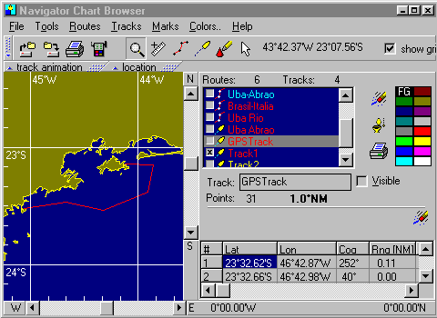
At anytime you can check the COG and Range between two points of a route, and the total length of a route. To edit a route, click the checkbox "Edit routes/tracks". The route editor will show. You can change all attributes of a route (Color, Name, and Visible). You can also edit coordinates of points, by double-clicking the point in the spreadsheet. To add a point to an existing route (or track), click the route tool. In the menu, select Routes Add Point to route. Choose the route. Add one or more points. Right click to save points and end addition.

To create a new route, click the route tool and click the route points. Right click end route. When prompted, enter route name.

Tracks - This tool is used to draw tracks. Tracks are like routes, except that each track point has an associated date/time value. They are used to log the positions on a trip. Like routes, they can have any number of points. Tracks can be stored in Navigator Desktop files (.NAV files). You can make tracks invisible to concentrate on your current track. You can also edit tracks, change their colors and names.

To edit a track, click the checkbox "Edit routes/tracks". The track editor will show. You can change all attributes of a route (Color, Name, and Visible). You can edit point data, by double-clicking the point in the spreadsheet.

To create a new track, select the track tool and click the first route point (left button). If you want, add more points with left clicks. When done adding points, right clicks the chart. Enter track name.

To add a point to an existing track, click the route tool. In the menu, select Tracks Add Point to route. Choose the track. Add one or more points. Right click to save points and end addition.

Marks- You can also add marks to the desktop. Select the mark tool and click one point, specify optional text for the mark and choose a mark icon.

Pointer- Use the pointer tool to point chart objects (islands, tracks, marks etc). If a name is associated with the object, a text will appear near the cursor.


Navigator Desktop files

back to the top

After loading a vector chart and/or raster charts; changing routes or tracks, you can save all to a desktop file. A Navigator desktop file contains the state of the chart viewer, including:

- One Vector charts.
- Raster charts (i.e. chart images)
- Routes
- Tracks
- Marks

Desktop files have the extension .NAV, and are in text format.


GPS Interface

back to the top

Navigator has GPS interface. This interface accepts NMEA (National Marine Electronics Association) standard GPS messages. Two kinds of NMEA messages are accepted:

RMC - Transit Specific Navigation information message- This is the recommended (default) accepted message, because it has date and course information. RMC messages give Latitude, Longitude, date, time, course and speed.

GLL - Geographic Position Latitude/Longitude message - Select this one if your GPS does not support RMC messages. GLL messages have only Latitude, Longitude and time (no date).

Note: The NMEA interface, available in most GPS devices, uses a RS422 hardware interface. This is not the same as the RS232c serial interface, available in PCs. While the 422 interface uses +12/-12V electric signals, the RS232 uses 0/5V. But since the PC uses the level of about 3V to distinguish between 0s and 1s, the connection works fine in most cases. However, they are different things, and you may experience problems connecting them.

You will need a connection cable, which is an optional part for some GPS models. Check your GPS documentation for more details on activating the NMEA interface and selecting the messages. Some GPS devices disable the dataport, to save battery. You probably will have to change the default configuration to enable the GPS data output.

To open the GPS interface dialog click the GPS Interface button. A window will show, with current GPS position. Clicking the Settings button will show the GPS settings page, as shown below. Clicking again hides the settings.

  • Set the baud rate to the same value as your GPS device. Most GPSs have a default baud rate of 4800.
  • Choose computer port number.
  • Click the "connected" checkbox to open the communications port and start receiving GPS data.

The upper panel will show the current position, date/time and position status (as reported by GPS device).

The GPS interface can be set to save a position periodically (AutoSave feature). Positions are saved to the current GPS track. A given desktop can have only one GPS Track. Use the "Choose GPS Track" button to choose the GPS track. If starting a new travel, use the "New track" button.

You can also save positions manually, by clicking the "Save position!" button. Just make sure the current position status is "valid".

Tip: If you use RMC messages, Navigator will plot a small boat in the current position, pointing to the actual course. If you use GLL, which has no course information, a square will be plotted.


Troubleshooting the GPS connection

back to the top

PC/GPS connections are sometimes tricky. A problem of either PC or GPS settings will unable the communication.

First, make sure that the GPS device is transmitting data. Stop the Navigator and open the Windows terminal (or Hyperterminal in Windows 95/98). Set terminal communications settings to 4800 baud, 8 data bits, parity None, 1 stop bit. If the GPS device is set correctly, you will see text messages coming from the GPS, like these:

$GPRMC,001556,A,2332.648,S,04642.969,W,000.9,045.8,230997,018.5,W*6E
or 
$GPGLL,2337.479,S,04718.352,W,235808,V*3

The first is a RMC message and the second a GLL. If you don't see any message, the GPS is probably not sending data. You may have to activate the GPS dataport and/or the transmission of each message type (Some GPS devices disable the data port every time they are turned off). After you start receiving one of these messages (choose RMC if available), return to the Navigator and make sure the correct data port, baud rate and NMEA message type are set. You may set the Navigator's GPS interface to beep on each incoming message.


Leg Calculator

back to the top

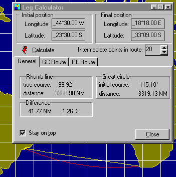
When planning a route between two points far away (over 1000 NM), many issues must be carefully considered: sea currents, prevailing winds, ship routes, shallow and dangerous areas, foul weather, etc. While these points are very important, there are also geometric considerations: the Earth is a sphere and routes are not straight lines but arcs in the spherical surface. Two kinds of routes are of special interest: the lines of great circle and the rhumb lines.

A Line of great circle (LGC) is the shortest path between two Earth points. This kind of route is contained in a plane defined by three points: the two route end points and the center of the Earth. When plotted in a Mercator chart, a LCG is represented by a curve, and a straight line in Gnomonic charts. While LGCs are shortest, they have a few problems:

  • True course changes constantly from point to point.
  • Depending on the end points, a LGC can take you to high latitudes, which is sometimes undesirable.

Rhumb lines (RL) are routes with constant true course. They are represented by straight lines in Mercator charts and curves in Gnomonic charts (the opposite of LGCs). RLs are easy to navigate because the course is constant. They are, however, a little longer (the difference is larger in higher latitudes).

Navigator Leg Calculator will calculate both LGC and RL routes between the two end points. To open the Leg Calculator, press the calculator button in the toolbar or choose 'Routes, Leg Calculator' in the menu.

Besides distance and course, Navigator shows the difference between the two options and builds routes with specified number of segments.

These routes can be inserted in the current desktop. Routes are added to the desktop with names "Rhumb Line" and "Great Circle". You may change these names in the route editor.

In the picture to the left, the yellow line is the RL route and the red one is the LCG (both created with 22 points). The difference between the two is 41.8 NM (1.26%). The LGC route has a crosstrack difference of 241 NM to the RL route (that is, it goes up to 4° south of the RL).

When building the routes, LGC route points are set by the program at constant longitude increments. RL route points are set at constant distance increments.


Chapter 4- ChartMaker program

The ChartMaker program was designed to work with chart images in formats GIF, JPG and BMP, and prepare them for use in the Navigator chart viewer.

This program has two main functions:

  1. Importing a raster chart images, producing CID files.
  2. Making vector charts (i.e. digitalizing points and polygons), producing CHT files.
How it works

back to the top

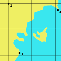
A computer image is formed by a large number colored dots - also known as pixels - disposed in a rectangular mesh. If the image is from a nautical chart or satellite photo, an algorithm can be designed to find the real world coordinates of any of these pixels and vice-versa. This is exactly how ChartMaker works.

The first step to make a vector chart or to import a raster chart image is to establish the scale model between the image and the real world. To do this, you have to click 3 reference points and enter their world coordinates (Lat/Lon pair). This is enough to define a scale between the real world and the image pixels.

Technically, when you click the three reference points and enter the Earth coordinates, you are actually defining four vectors: two in screen coordinates (S12 and S13) and two in Earth coordinates (E12 and E13). Since both geometries are similar, for any point P, we can write:

SP = S1 + k * S12 + r * S13
EP = E1 + k * E12 + r * E13

(1)
(2)

where:
SP = Screen coordinates of point P
EP = Earth coordinates of point P
S1 = Screen coordinates of reference point 1
E1 = Earth coordinates of reference point 1
r and k constants

From relation (1), we can calculate constants k and r. With these constants, we can calculate the earth coordinates of P from relation (2). This is how the program calculates the earth coordinates of any screen point (and screen coordinates of a Lat/Lon pair).


Mercator Latitude scale correction

back to the top

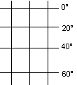
The method above works for linear latitude and longitude scale charts. But most navigation charts (and particularly the detail charts) are Mercator projections. Mercator projections have a great advantage: distances and courses between points can be measured directly from the chart. Angles are true, no correction is needed.

As any coast navigator knows, distances in these "regular" charts must be measured in the latitude scale, one minute of latitude being one nautical mile. To allow this, the Mercator projection latitude scale is not linear.

If you look at the picture below, you will see that, as latitudes get higher, distance between parallels in Mercator charts expands. The size, measured in screen pixels, of a given latitude minute is proportional to 1/cos(Lat). For instance, when Lat=0, cos(0)=1.0. For Lat=60°, cos(60)=0.5, and so a minute of latitude at this point twice as large as at Lat=0. Of course this "latitude grow" is variable, and integral calculations are needed to calculate the size factor between two latitude intervals.

Navigator's screen chart representation is not a Mercator chart. The latitude scale is linear and the factor between latitude and longitude axis tick sizes is equal to Mercator projections in the center of the chart window. This is, however, of no consequence, since you are not going to "measure" anything on the screen. You will use programs calculators and measurement tools, which use the mathematically perfect Lines of Great Circle (LGC) for distance and course calculations.

Still, Navigator knows how to deal with Mercator chart images. When using a Mercator chart image on the Navigator, remember to check the Mercator latitude scale checkbox. The program will correct for the Mercator scale automatically.


Which chart images can be used ?

back to the top

  • Mercator chart images are OK, even if the image is rotated (like chart 1 on the left). It's difficult to perfectly align a large chart when scanning. ChartMaker will rotate the chart in order to align its grid with the vertical direction (chart 2). This is necessary to speed up chart resampling, for displaying.

  • Gnomonic and other curved grid projections cannot be used.

  • Some images (particularly satellite images) are skewed. Their constant latitude and constant longitude lines are not orthogonal (like chart 3 on the left). These images cannot be used. After entering the three reference points, Chartmaker will inform you if this kind of problem is present.
Tips for scanning charts

back to the top

  • Scan using resolutions between 75 and 150 dpi. Avoid large files (over 1MB GIFs or JPGs). Images will have to be ressampled by the Navigator at run time while zooming. Large images will consume a lot of CPU cycles, resulting in poor and bumpy performance.
  • When scanning large paper charts, you may detach the page scanner cover (if the scanner allows) to avoid folding the chart. Put some weight over the scanner cover, so that the paper is flat and perfectly in contact with scanner bed.
  • If the chart doesn't fit in the scanner bed, scan it in parts, overlapping between them. Then make a CID file for each image. Navigator can display different charts together, and will even allow partially opaque rendering, merging the overlaps.
  • Larger scanners (A3) are preferred, when available. A4 scanners are small for large paper charts.
  • Hand scanners are not recommended, because they can distort the image scale. Use only page scanners.
  • Images should be saved in GIF or JPG format (JPG is usually better).


Choosing the 3 reference points

back to the top

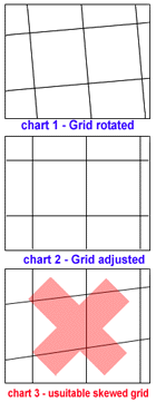
The 3 reference points indicate how the pixels in the chart image map to the actual world. Care must be taken in choosing these points, in order to achieve a precise scale. Below are some guidelines for choosing the reference points:


bad points- too close!

Choose reference points that are as far from each other as possible. This will result in a more precise scale. If possible, choose points near the corners of the image. In the image on the left, points are too close and the scale will be poor.


bad points- nearly aligned!

Reference points must not be aligned. In the image on the left, points are nearly aligned and the scale will be poor.


good reference points

In the image on the left, points are well positioned (i.e. far from each other and not aligned). Choose points that are close to the corners of the image, if possible.

If the chart has a grid, the grid line crossings are logical candidates for reference points (like point 2). But other points can be used and they don't need to define a right angle between them.


Importing a raster chart image

back to the top

  1. Open the chartmaker program and click Import chart image and load the image to be imported.
  2. Check the Mercator scale checkbox, if chart is a Mercator projection (most are).
  3. Take a good look in chart and choose the 3 reference points, as described above. Click each reference point with great care. Inform the precise latitude and longitude for the point.
  4. Chartmaker will then calculate the scale and produce a summary, rotating the image as needed (rotation is considered necessary if the angle between a meridian and the vertical is larger than 0.001 rad).
  5. If the image was rotated by ChartMaker, you must save it. I use to save the image with a different name, keeping the original scan intact, but you may save with the same name, ovewriting the original.
  6. If you made any mistake or if the image is unsuitable for use, the summary will inform you of this. You may try again, if you think the image is suitable and you made a mistake.
  7. After the summary, you can click extra points in the chart. This is optional, but highly desirable, to further check if any error was done in the reference points.
  8. If everything is OK, save the CID file (Chart Image Definition). This text file contains the information for the Navigator program to use the image: the reference points data, image file name and description.
  9. The CID file also contains the image digital signature (of type MD5). This is to make sure that the associated image is unchanged. So, if you do any changes in the image - even changing a single pixel color, the CID file will become invalid. This is a security feature to avoid accidental image change.


Making vector charts

back to the top

While raster charts are very complete, with the all relevant navigation information, vector charts cosume less memory, are a lot faster to draw and are "zoomable". This is why is interesting to have a vector chart to be loaded underneath the local raster charts.

Navigator uses a custom chart file format, with the CHT extension. These are plain text ASCII files and can be edited with the Windows Notepad or Wordpad. Because providing detailed vector charts of all regions of the Earth is a demanding task, I choose to give users a tool to roll their own charts. Producing a vector chart means using a raster chart image to digitalize the points in the shoreline.

Chartmaker accepts three image formats: Windows BMP, GIF and JPG. If you are scanning paper charts, JPG is probably the best format, because files are smaller. It's a compressed format.

The CHT file

Once you have the image of the chart, load it in Chartmaker. Now you have to define the scale for this chart. Click and enter the Earth Coordinates for three distinct reference points of the image, as described above.

  1. Choose three points that are relatively distant to each other (at least 1/3 of the screen). Select points that form a right angle. Click the points and enter their Earth coordinates.
  2. After the third point, the caption will show the coordinates of the cursor, as you move the mouse. Check the coordinates of other points, to certify that your scale is accurate.
  3. Select "Edit, Draw Axis" in the menu. The program will draw vertical and horizontal axis in 30' intervals. Check if they are the same as the image's axis. Draw again to erase the axis.
  4. Now draw the shoreline, clicking the points with the mouse. Draw different polygons to represent the islands and continents.
  5. After clicking all points of a given polygon, press the "close polygon" button. The last point will be connected to the first. All polygons must be closed.
  6. Give a name for the polygon.
  7. After drawing all the polygons, save the CHT file.
  8. Open it in Navigator chart viewer, to see the result. Zoom in and out, to check the details.

In the figure to the left, the 3 reference points are marked 1, 2 and 3. The coordinates are:

1) 24°00.0S 46°25.0W 
2) 23°50.0S 46°25.0W 
3) 24°00.0S 46°06.6W
If you open the supplied myworld.cht file in Navigator, you will see a simplified chart of the whole world. I made it more detailed in one part (44°00'W 23°30'S), the region I usually navigate. You can do this for your region, by directly editing the CHT file with a text editor and adding the polygons of your region. This is a little tricky. You might prefer to roll a chart of your region only.

You may also merge CHT files, using an ASCII text editor (like the Notepad or Wordpad). Take a look in the CHT file header for more technical details on the CHT file format.

xxx

(c) Copr. 1991-2001 Omar F. Reis - All rights reserved


©Copr 92-2012
Omar F. Reis - All rights reserved