
User Manual
VRTool sidekick (VSK) combines a sailing calculator and
a GPS logger. It
transforms your GPS enabled phone in a powerful
sail boat racing tool. VSK is useful alone, but is designed to work in concert
with VRTool on the desktop.
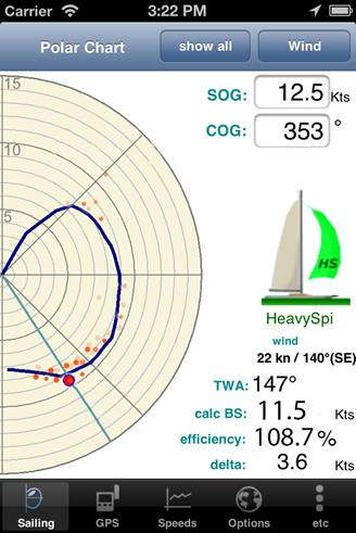
While sailing, VSK monitors your current sailing
performance. VSK uses the GPS position,
current wind conditions and boat polar
chart to calculate and show sailing data. This is displayed as text and plot on
the polar chart.
As a GPS logger, VSK can be set to save boat
positions and other sail variables periodically. The points can later be
uploaded to VRTool
desktop for further analysis and document of your sailing legs.
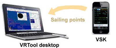
VRTool desktop allows
track planning, weather routing optimization using NOAA wind
forecasts, chart visualization with vector charts, winds, marks, routes and
tracks.
VRTool embedded web
server can be used to share sailing information with the crew using onboard
mobile devices.
To learn about VRTool
desktop software, visit www.tecepe.com.br/nav/vrtool
Installing and
configuring VSK
VSK is available from the AppStore. Once the app is installed comes the hard part:
you must obtain and install the polar
chart for your particular
kind of boat.
The polar chart is a
set of curves, for a number of wind speeds, relating wind speed & wind angle
to boat speed. You can use it to compare actual boat speed to the optimized
speed from the chart.
Data for the polar chart can be obtained from boat
manufacturer or designer. In most cases, it is available as an image or
spreadsheet - and has to be imported. Use VRTool
Polar Studio for that.
Even if you obtain
data from the manufacturer, actual figures may be different due to the
particular set of sails, boat weight, mast, propeller type etc.
You can also roll
your experimental curves, using data gathered during sailing sessions. Either
way, it is a lot of work, but necessary to get the most out of VSK/ VRTool
calculators.
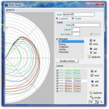
VRTool Polar Studio
VSK accepts VRTool compatible
multi-sail polars, (*.XML). Use the Polar Studio (a module of VRTool
desktop) to create and graphically edit your boat curves.
You can also use an
ASCII text editor, if you feel comfortable editing raw XML. Too see how a
VRTool polar chart file looks like, click here.
Once you have your
polars ready, upload it to a web server (i.e. in the cloud). You can use any
internet service that allows file uploads and downloads.
VRTool desktop itself
can be used as a web server. The web server has to be running anyway to interact
with VSK.
1) On the PC, place your polars in
<program files>\VRTool\htdocs\
This is the VRTool
web server document root folder
2) Activate VRTool embedded web server.
3) In VSK, set url to the polars file. For example: http://192.168.0.100:8080/polarsBavaria38.xml
Some sample files can be found in:
Bavaria 38
www.tecepe.com.br/polars/polarsBavaria38.xml
Elan 33
www.tecepe.com.br/polars/polarsElan33.xml
J-24
www.tecepe.com.br/polars/polarsJ24.xml
J-92 deep keel
www.tecepe.com.br/polars/polarsJ92DeepKeel.xml
In VSK select tab Options. Type
the polars location (URL) and press
[download polars XML] button.
If the download is
successful, the boat model appears (see image below). Once the file is
installed, you no longer need an Internet connection. The file persists, even
if the app or the phone is restarted.
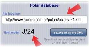
download from a web server
Connect the phone to the desktop
To send saved points
from VSK to VRTool, both the phone and the PC must be connected to the same
network. Use a wireless router or the phone access point to establish a
wireless intranet around your boat (more on this here)
Working with VSK
VSK uses the phones internal GPS
to calculate your current boat speed and course. You have input the true wind (no direct
instrument interface is available at this time). VSK shows:
·
True Wind Angle
(TWA)
·
Calculated Boat
Speed (calc BS)
·
Speed
efficiency (actual boat speed/calculated speed)
·
Recommended
sail (requires
multi-sail polars)
The chart shows your
sailing point (fat red dot) and the polar chart line for the current wind
speed.
In the Sailing tab we have
two input fields:
·
SOG ( boat
Speed Over Ground - in knts)
·
COG
( Course Over Ground )
You can type in the
boat speed/course manually, or you can let VSK update those automatically,
using GPS readings.
You have to input (and
keep updated) the true wind parameters ( TWS/TWD ).
Press the [Wind] button.
A small panel opens and let you type:
·
TWS (True Wind
Speed) in knts
·
TWD
(True Wind Direction)
Click [ok]
button to accept the new wind parameters.

Sailing tab
Click the [Show
all] button to show all polar lines, for various wind speeds.
When a GPS tick is received, only the line for current wind speed is shown.
Checking
option [x] Sticky points plot will show up to 100 previous sailing
points on the chart. Older points are fainter. If you change wind speed, sticky
points are cleared.
You can turn the GPS
device on/off by using the GPS switch, on GPS tab.
Note: the GPS has to
be turned on each time the app is restarted.
For each position
received, VSK calculates:
·
SOG ( boat
Speed Over Ground )
·
COG
( Course Over Ground )
·
TWA
(True Wind Angle )
Input the leg destination position
(the next mark in the race).
1.
Click the [
i ] button to edit the latitude and longitude of destination,
using decimal notation.
2. Use negative
values for South latitudes and West longitudes.
For example, to input 23°30'S/46°30'W,
type -23.5 and -46.5.
3.
Press [ok] to accept.
If the leg
destination is set, the program also calculates:
·
Distance to
destination
(uses great circle calculation)
·
Direction to destination
·
VMC (Velocity
Made good to Course) This is the
projection of boat speed in direction of destination (the useful part of the actual
boat speed)
The boat attitude
chart shows the wind vector (blue arrow) and destination direction (orange
arrow below).
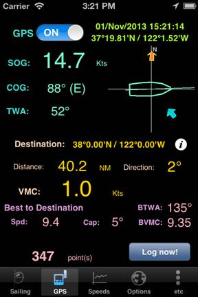
GPS tab
In the bottom there
is the Best to Destination section.
This is the course with the best VMC possible to the destination, with current
wind conditions. It shows:
·
calculated boat speed (Spd)
·
Best course to destination (Cap)
·
Best True Wind Angle (BTWA)
·
Best VMC to destination
In the Logger tab you can
configure and share the GPS points you have saved in the current sailing
session.
Inform your boat name. This will be
used to identify the boat track that will receive the points. The points you
send to VRTool will be added to the end of a track named TR_boatname. If it doesnt exist, VRTool creates a new track.
Tip: Multiple
boats can send points to the same VRTool host, if they are connected to the
same network.
VRTool software
receives data from VSK in its embedded web server, which must be active to
receive points. See VRTool documentation
and WIKI about this.
In the image bellow, note the address pointed by the red arrow. This is the
network address of the VRTool embedded web server.
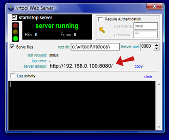
VRTool embedded webserver
Input the HOST:PORT part to the VSK Logger settings
(in this case, the IP number "192.168.0.100:8080").
The GPS sensibility
parameter controls how often the GPS device informs positions. If too small,
you get instable speed readings ( due to imprecision of GPS positions). If too
large, it takes too long to update (default=50m).
You can control the
periodicity of logged points (all ticks, 1 min, 10 min, 1 h , 1 day). Or you
can choose to disable automatic logging and do it manually, by pressing the [Log
now!] button, in the GPS tab.
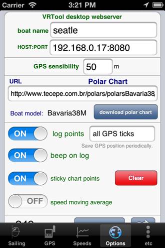
GPS Logger options
Saved positions can be
shared:
·
By E-mail using button 
·
Copy-paste
to Notes
·
Upload to VRTool desktop, using
[Send Points] button
(remember to configure the VRTool host before uploading points).

points sent to VRTool
Note: for VSK
compatibility, make sure you have VRTool 2.20+ or Navigator 6.0+ on the PC.
In tab
Speeds there is a boat speed chart (see below)
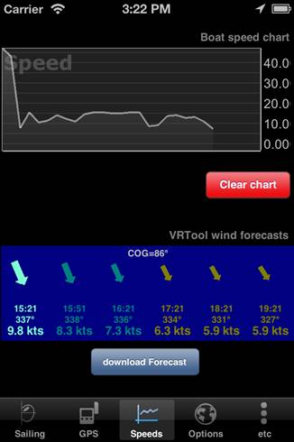
It shows the
boat speed in kts. Use the [Clear chart] button to clear.
The blue
panel imports the wind forecast for the next couple hours from VRTool. VRTool
must have valid forecasts loaded for the current location. Make sure the VRTool
webserver is running, and the option is configured in VSK.
For this
forecast, current speed and course are considered. If you click download and
nothing happens, wait for the download to timeout (up to 30 seconds). If you
receive and error message, check configuration.
VRTool website,
forum and WIKI: http://www.tecepe.com.br/nav/vrtool
V
1.2 oct/2013
©Copr 2013 Omar
F. Reis