Difference between revisions of "Other Tab"
(→Forecast Age) |
(→Starting from your current position) |
||
| Line 29: | Line 29: | ||
|[[File:VRLogo.gif|left]]'''''Tip for Virtual Regatta games:''' When France moved from CEST to CET in October 2014 Virtual Regatta adjusted their game clock so that game updates would happen at the same '''local time''' in France. This is instead of keeping the times consistent with UTC. This means that forecasts are now applied to VR games '''one hour late'''. For example a forecast issued by NOAA for 0600 UTC is now applied to VR games at 0700 UTC.'' | |[[File:VRLogo.gif|left]]'''''Tip for Virtual Regatta games:''' When France moved from CEST to CET in October 2014 Virtual Regatta adjusted their game clock so that game updates would happen at the same '''local time''' in France. This is instead of keeping the times consistent with UTC. This means that forecasts are now applied to VR games '''one hour late'''. For example a forecast issued by NOAA for 0600 UTC is now applied to VR games at 0700 UTC.'' | ||
| − | ''VRTool applies NOAA forecasts at the '''correct''' time (because it also has to work for real world navigation). So if the time is set correctly in VRTool its weather model shifts to the next forecast one hour before the game does.'' | + | ''By default VRTool applies NOAA forecasts at the '''correct''' time (because it also has to work for real world navigation). So if the time is set correctly in VRTool its weather model shifts to the next forecast one hour before the game does. You can make VRTool apply the forecasts an hour late by setting the time zone '''in this panel''' to one hour '''west''' of your actual time zone.'' |
| − | '' | + | ''Be aware that if you do this, and you then download new weather during the hour following 06:00 or 18:00 UTC, VRTool will think it has a forecast with a '''negative''' age and the routing won't work for that hour! Everything is fine if you keep using your previous download through this period.'' |
| − | ''This | + | ''Don't change your PC system time zone or the setting in the NOAA download module - they both have to interface with the real world.'' |
| + | |||
| + | ''This shambles is the reason the prime meridian was internationally standardised at Greenwich back in 1884!'' | ||
|} | |} | ||
Revision as of 02:52, 5 November 2014
![]() The following control panels are on the Other tab:
The following control panels are on the Other tab:
Contents
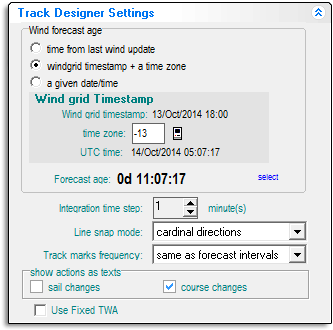
Track designer settings
This control panel is a little difficult to understand at first, but it's very important to get it right. Otherwise your weather routing and track designs will be wrong and you may not know it.Here's what it does: When you have weather loaded VRTool has access to wind data for a whole range of times. When you start a new track on the chart, or start a new weather route, VRTool needs to know which point of time in this weather continuum to apply to the start of the track. The settings on this control panel do this alignment between your track and the wind data.
There are three alternative methods - choose the appropriate one depending on where on the chart you intend to start the track or weather route.
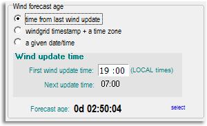
Starting from your position at the last wind update
Use this method if you are starting a track from the position you were at when current weather data begins.This option starts applying weather from the beginning of the weather data. Enter the wind update time for the last forecast in the [First wind update time] field. This field then updates automatically as the game proceeds.
This option is historical and is not very useful - it has been superseded by the next two options:
Starting from your current position
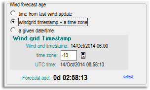
Use this method if you are starting a track from the current position of your boat. This is what you will normally be doing. Think of it as the "current wind" option.VRTool looks up the current time in the weather files and starts using data from that point. Weather data is stamped with UTC time, so VRTool needs your time zone to convert your local time to UTC before it does the look-up. Put this in the [time zone] field. Provided you are not doing something unusual with your system settings you can automatically fill this field by clicking in the ![]() icon.
icon.
| Tip for Virtual Regatta games: When France moved from CEST to CET in October 2014 Virtual Regatta adjusted their game clock so that game updates would happen at the same local time in France. This is instead of keeping the times consistent with UTC. This means that forecasts are now applied to VR games one hour late. For example a forecast issued by NOAA for 0600 UTC is now applied to VR games at 0700 UTC.
By default VRTool applies NOAA forecasts at the correct time (because it also has to work for real world navigation). So if the time is set correctly in VRTool its weather model shifts to the next forecast one hour before the game does. You can make VRTool apply the forecasts an hour late by setting the time zone in this panel to one hour west of your actual time zone. Be aware that if you do this, and you then download new weather during the hour following 06:00 or 18:00 UTC, VRTool will think it has a forecast with a negative age and the routing won't work for that hour! Everything is fine if you keep using your previous download through this period. Don't change your PC system time zone or the setting in the NOAA download module - they both have to interface with the real world. This shambles is the reason the prime meridian was internationally standardised at Greenwich back in 1884! |
Starting from some other position
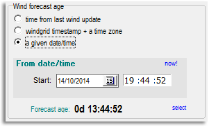
Use this method if you are drawing a track starting from any arbitrary position. This is useful if you want to start a track or weather routing from a position that you expect to be in some time in the future, for example at a rounding mark further up the course.To do the alignment you need to estimate when you will be at that position and tell VRTool to start using weather data for that time. In the [From date/time] field enter the start time in UTC.
| Careful: As of version 2.30, clicking in the now! link returns the current local time, not the current UTC time. If you want to enter the current time here you must correct the hour to UTC, before adjusting it forward to the estimated time for the start position. |
Forecast Age
For each method the Forecast age is displayed at the bottom as a check. This is the age of the weather that will apply at the start of the track. The age is measured from the beginning of the weather data that VRTool has in its database.
For example: Lets say VRTool has weather loaded that begins at 07:00:00 local time. At 10:30 am you want to draw a track (or start weather routing) starting at your current position (using the second method above). The forecast age should display 0d 03:30:00. In other words you are starting three and a half hours into the available weather data. If it displays something different then the weather is not correctly aligned.
Similarly if you want to start a track from a position you expect to be in at say noon local time (using the third method above) then the forecast age should display 0d 05:00:00.
| Tip: If the forecast age is 12 hours older than it should be it usually means the weather in VRTool's database is not up to date. Weather routing should still work but using old predictions rather than the latest data. You should do a wind update first. |


