Difference between revisions of "Other Tab"
(→Track designer settings) |
(→Track designer settings) |
||
| Line 8: | Line 8: | ||
There are three alternative methods - choose the appropriate one depending on where on the track you intend to start the track or weather routing.<br style="clear: both" /> | There are three alternative methods - choose the appropriate one depending on where on the track you intend to start the track or weather routing.<br style="clear: both" /> | ||
| − | [[File:CPTrackDesignerSub1.gif|left]] | + | ===Starting from your position at the last wind update=== |
| − | Use this if you are starting a track from the position you were at when the forecast arrived. | + | [[File:CPTrackDesignerSub1.gif|left]] Use this if you are starting a track from the position you were at when the forecast arrived. |
This option starts applying weather from the time of the last wind update. | This option starts applying weather from the time of the last wind update. | ||
| Line 17: | Line 17: | ||
<br style="clear: both" /> | <br style="clear: both" /> | ||
| − | [[File:CPTrackDesignerSub2.gif|left]] | + | ===Starting from your current position=== |
| − | Use this method if you are starting a track from the '''current position''' of your boat. This is what you will normally be doing. Think of it as the "current wind" option. | + | [[File:CPTrackDesignerSub2.gif|left]] Use this method if you are starting a track from the '''current position''' of your boat. This is what you will normally be doing. Think of it as the "current wind" option. |
VRTool looks up the current time in the weather files and starts using data from that point. Weather data is stamped with UTC time, so VRTool needs your time zone to convert your local time to UTC before it does the look-up. Put this in the '''[time zone]''' field. Provided you are not doing something unusual with your system settings you can automatically fill this field by clicking in the [[File:IconLisa.gif]] icon. | VRTool looks up the current time in the weather files and starts using data from that point. Weather data is stamped with UTC time, so VRTool needs your time zone to convert your local time to UTC before it does the look-up. Put this in the '''[time zone]''' field. Provided you are not doing something unusual with your system settings you can automatically fill this field by clicking in the [[File:IconLisa.gif]] icon. | ||
| Line 26: | Line 26: | ||
|} | |} | ||
<br style="clear: both" /> | <br style="clear: both" /> | ||
| − | + | ===Starting from some other position=== | |
| − | [[File:CPTrackDesignerSub3.gif|left]] | + | [[File:CPTrackDesignerSub3.gif|left]] Use this method if you are drawing a track starting from any arbitrary position. This is useful if you want to start a track or weather routing from a position that you expect to be in some time in the future, for example at a rounding mark further up the course. |
| − | Use this method if you are drawing a track starting from any arbitrary position. This is useful if you want to start a track or weather routing from a position that you expect to be in some time in the future, for example at a rounding mark further up the course. | ||
To do the alignment you need to estimate when you will be at that position and tell VRTool to start using weather data for that time. In the '''[From date/time]''' field enter the start time in '''UTC'''. | To do the alignment you need to estimate when you will be at that position and tell VRTool to start using weather data for that time. In the '''[From date/time]''' field enter the start time in '''UTC'''. | ||
Revision as of 07:24, 15 October 2014
![]() The following control panels are on the Other tab:
The following control panels are on the Other tab:
Contents
Track designer settings
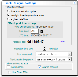
This control panel is a little difficult to understand at first, but it's very important to get it right. Otherwise your weather routing and track designs will be wrong and you may not know it.Here's what it does: When you have weather loaded VRTool has access to wind data starting from the beginning of the first forecast right through to the end of the last. When you place a point on the chart to start a new track VRTool needs to know which point of time in this weather continuum to applies to the start of the track. The settings on this control panel do this alignment between your track and the wind data.
There are three alternative methods - choose the appropriate one depending on where on the track you intend to start the track or weather routing.
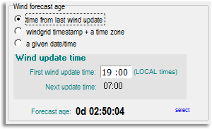
Starting from your position at the last wind update
Use this if you are starting a track from the position you were at when the forecast arrived.This option starts applying weather from the time of the last wind update. Enter the wind update time for the last forecast in the [First wind update time] field. This field then updates automatically as the game proceeds.
This option is historical and is not very useful - it has been pretty much superseded by the second option:
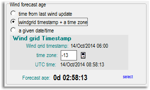
Starting from your current position
Use this method if you are starting a track from the current position of your boat. This is what you will normally be doing. Think of it as the "current wind" option.VRTool looks up the current time in the weather files and starts using data from that point. Weather data is stamped with UTC time, so VRTool needs your time zone to convert your local time to UTC before it does the look-up. Put this in the [time zone] field. Provided you are not doing something unusual with your system settings you can automatically fill this field by clicking in the ![]() icon.
icon.
Starting from some other position
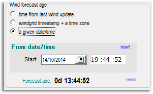
Use this method if you are drawing a track starting from any arbitrary position. This is useful if you want to start a track or weather routing from a position that you expect to be in some time in the future, for example at a rounding mark further up the course.To do the alignment you need to estimate when you will be at that position and tell VRTool to start using weather data for that time. In the [From date/time] field enter the start time in UTC.
| Careful: As of version 2.30, clicking in the now! link returns the current local time, not the current UTC time. If you want to enter the current time here you must correct the hour to UTC, before adjusting it forward to the estimated time for the start position. |


