Weather routing tips
Vrtool weather routing has a many parameters, to allow flexibility in all possible situations and scales. But this also gives ample opportunities to mess up. If weather routing is not properly configured, the calculation can quickly scale out of control, taking a lot of memory and cpu power.
Weather routing parameters
The following configurations are suggestions. Actual values depend on the CPU power and memory of the computer. Adjust the configuration as needed (see below).
![]() For VORG you may use the following parameters:
For VORG you may use the following parameters:
- Use the polars database provided with version 2.0.
- Use NOAA winds.
- Interval= 1 (or 0.5)
- Up to isochrone=72 to 384 (make sure the correspondent wind forecasts are loaded)
- number of branches=29 to 41
- max angle to destination=120
- show isochrones=6h
- wake angle=35
- Iso point spacing=1.5 (%)
- [x] Collision detection (checked)
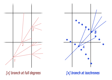
- [x] Add branches at isochrones (checked)
- [ ] Add branches at full degrees (unchecked)
![]() For Virtual Regatta you may use the following parameters:
For Virtual Regatta you may use the following parameters:
- Use the polars database from vrtoutoulz [1] .
- Use game winds, vrtoutoulz or NOAA winds.
- Interval= 1 (or 0.5)
- Up to isochrone=72
- number of branches=19
- max angle to destination=100
- show isochrones=6h
- wake angle=40
- Iso point spacing=1 (%)
- [x] Collision detection (checked)
- [ ] Add branches at isochrones (unchecked)
- [x] Add branches at full degrees (checked)
Each isochrone set is marked with a time label (p.e. 12h, 24h)
This is the point closest to the WR destination.
Note that you cannot connect these points, because they don't belong to the same route.
If you want to know the route that will take you to a certain isochrone
best point (for example 48h), set "Up to isochrone" parameter to 48 and recalculate.
Wind forecast Age
One important configuration that affects both the Track designer and Weather Routing is the forecast Age. This tells the program how old the current wind forecasts are. To configure that, go the the Other tab in the main program form, locate the Track Designer Settings Panel. Select [x]Grid Timestamp + Time Zone and set your system time zone (p.e. 3 for GMT+3) Note the Forecast Age value. If you are 10h into the current wind shift, it must show 10:00:00.
Weather routing module parameters explained
Start and destination positions - Weather routing calculation is always done between two end points. The Start must be set to the current boat position. Click the target button and point your current boat position in the chart, or type lat/lon. The Destination can be either the final leg destination or the next leg mark. If the leg has intermediate marks, you must go one segment at a time.
isochrone interval - Time between successive isochrones, in hours. Note that, when crossing a isochrone, the software does the tree pruning, reducing the point count. Longer intervals will result in large number of points and sluggish calculation. Use 1 or 0.5 hours.
up to isochrone - This sets the time horizon of the calculation, in hours. The best route will be the one that ends up closest to the destination in the specified time. Note that using long term forecasts (120 to 384h) can be deceiving. Short term forecasts are more reliable than long term ones. You may reset the "Up to isochrone" parameter to a smaller number (say 36 or 48) and perform another calculation. If both routes (short and long term) point to the same direction, one can be confident. If they differ a lot, the situation requires a more detailed analysis. This time is always in relation to the last wind shift, so if you are 10h into the current wind shift, using up-to-isochrone=12 will only calculate a 2h route.
number of branches - Number of track segments created at each branch generation. The software adds one track direct to the destination and a number segments to each side, spaced 5 deg (a little less in close hauled direction). So if you choose 21 for example, you have 10 segments to each side (up to 50 degrees). In the classic polar database there are 62 directions. Setting this param too high causes the computer to choke.
Max angle to the destination - removes branches that point more this angle to the destination. Use between 90 and 120.
iso point spacing - This is the density of points kept in the isochrone. Default is 1 (for 1% of the distance to start or destination). If you increase to 2, for example, you will keep fewer points, more spaced, resulting in a faster calculation, but with a little less detail.
[ ] Add branches at isochrones - When the boat reaches the isochrone, add branches in several directions. (should be checked for VORG. unchecked for VR)
[ ] Add branches at full degrees - Has to do with the wind rectangles in VR races. Do a round of branching when the boat crosses a rectangle border (Unchecked for VORG. Checked for VR) ( Parameter is misnamed, it is actually when the boat crosses the 30' lat/lon boundary )
[ ] Collision Detection - When set, program avoids routes that go over land. This should be checked most of the time. In some cases when the best route passes trough narrow channels, the weather routing may fail to find it. In such cases, disabling collision detection may help (of course you still have to avoid routes that go over land).
show isochrones - This controls which isochrones are exported to the desktop when you click [Add isochrones] button. Default = 6h.
[i]Tip:[/i] You don't have to restart the calculation if you change that,
because the track tree is still in the memory. You can change it and insert the isochrones again.
