Difference between revisions of "Importing NOAA Winds"
(→Download Parameters) |
m (→Transformations) |
||
| Line 33: | Line 33: | ||
[[File:NOAATransformVORG.gif|right]] These settings ensure that the downloaded GRIB is processed in the same way as the game server, so that the weather VRTool uses is indentical to the game. | [[File:NOAATransformVORG.gif|right]] These settings ensure that the downloaded GRIB is processed in the same way as the game server, so that the weather VRTool uses is indentical to the game. | ||
| − | The '''Grid Probe Resolution''' (set to 1°) sets the resolution of the data points in the downloaded GRIB file. These weather data points are displayed on the chart at 1° intervals. | + | The '''Grid Probe Resolution''' (set to 1°) sets the resolution of the data points in the downloaded GRIB file. These weather data points are displayed on the chart at 1° intervals. For the VORG the speed and direction is then interpolated between these points, so it is important to ensure that [[Wind Interpolation|wind interpolation]] is turned on in VRTool. |
== Running the Download == | == Running the Download == | ||
Revision as of 09:35, 30 May 2012
The winds used in the VR and VORG games are generated from weather GRIBs downloaded from NOAA's Global Forecast System. This weather is then processed by the game servers and fed to the game clients on players machines at the regular 12-hourly weather updates.
VRTool is able to import these same weather GRIBS imported directly from the NOAA server, independently of the game. This has the obvious competitive benefit that VRTool has updated forecasts well in advance of the 12-hourly game feed, allowing players to make early course adjustments for the future weather.
Winds are imported using VRTool's built-in NOAA Import Module. There are various configuration settings in the module to ensure that the correct forecasts are extracted from the NOAA server, and that the subsequent processing is consistent with the game servers.
The NOAA Import Module is started by clicking the Winds button on the main toolbar. (The same button is also available on the Wind Grids control panel in the "Winds" tab.)
Contents
Setting the GRIB Boundaries
With a broadband connection it is practical to download a very wide area of ocean. This means that even for a trans-oceanic leg is possible to set the GRIB boundaries once to cover the whole area of the whole leg, and then not touch it again. The module defaults to the last-entered boundaries. This simplifies both the downloads and the weather routing.
Zoom the chart out so that the whole area of the leg is displayed.
Start the NOAA Import Module and go to the Download from NOAA tab. Click on the top-left boundary handle, then click on the chart to pick up the co-ordinates for this point. Repeat for the bottom-right handle. The GRIB boundaries are now set for the whole leg.VORG 2011-2012 Settings
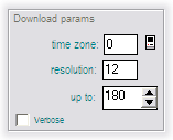
Download Parameters
Time Zone: Set this to your computer's time zone setting. You can click on the icon to retrieve this automatically. (Not sure what VRTool does with this.)| Tip: For users in the GMT +12:00 zone, clicking on the icon retrieves a system time zone of -12. The -12 setting works correctly. |
Resolution: Set to 12. This is the forecast interval in hours. (Not sure what VRTool does with this.)
Up to: Determines the number of forecasts downloaded. A setting of 180 downloads all the forecasts up to and including the +180 hour forecast. The normal maximum is 180. Reduce this setting if you know you will reach your destination in less time - this speeds up the download (and has another more important benefit).
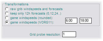
Transformations
These settings ensure that the downloaded GRIB is processed in the same way as the game server, so that the weather VRTool uses is indentical to the game.The Grid Probe Resolution (set to 1°) sets the resolution of the data points in the downloaded GRIB file. These weather data points are displayed on the chart at 1° intervals. For the VORG the speed and direction is then interpolated between these points, so it is important to ensure that wind interpolation is turned on in VRTool.
Running the Download
Advanced Topics
Time Zones
Time zones can be confusing. Real mariners keep a clock set to GMT. Similarly life in virtual regattas is much simpler if you set your game computer to the GMT time zone. However this may confuse some other applications, such as email clients.


