Difference between revisions of "DataFiles"
m (→Importing game winds and boat data) |
m (→Wind forecasts) |
||
| (44 intermediate revisions by 2 users not shown) | |||
| Line 1: | Line 1: | ||
VRtool needs data to perform calculations. Those have to be loaded in the program before you can use the track designer or the weather routing module, for example. These data files are charts, wind forecasts and polars. All VRTool data files are in text format, to allow easy editing and repairing files. | VRtool needs data to perform calculations. Those have to be loaded in the program before you can use the track designer or the weather routing module, for example. These data files are charts, wind forecasts and polars. All VRTool data files are in text format, to allow easy editing and repairing files. | ||
| − | == | + | == Vector charts == |
| − | + | VRTool uses a custom vector chart format, in ASCII text, with extension .CHT. | |
The program comes with a simple world map (world3.cht). | The program comes with a simple world map (world3.cht). | ||
| − | |||
| − | |||
| − | |||
| − | + | To load a vector chart, use menu option '''File > Open Vector Chart...''' | |
| − | + | Multiple charts can be open at the same time, by using '''File > Merge Vector Chart...''' | |
| − | + | ||
| + | == GSHHS charts == | ||
| + | A detailed set of charts covering the whole planet is the GSHHS database | ||
| + | (''Global Self-consistent, Hierarchical, High-resolution Shoreline Database'' [http://www.ngdc.noaa.gov/mgg/shorelines/gshhs.html]) | ||
| + | |||
| + | Version 2.3.4 of the database was released Jan. 1, 2015. | ||
| + | |||
| + | Translation of the GSHHS files to CHT format are available for download below. | ||
| + | |||
| + | Includes lakes, islands in lakes, antarctic ice front and ground line. Files are zipped. | ||
| + | |||
| + | *[http://www.tecepe.com.br/nav/gshhs/gshhs_f.zip Full resolution data ( 60 MB )] | ||
| + | *[http://www.tecepe.com.br/nav/gshhs/gshhs_h.zip High resolution data ( 14 MB )] | ||
| + | *[http://www.tecepe.com.br/nav/gshhs/gshhs_i.zip Intermediate resolution data ( 3.5 MB )] '''<-- recommended''' | ||
| + | *[http://www.tecepe.com.br/nav/gshhs/gshhs_l.zip Low resolution data ( 757 KB )] | ||
| + | *[http://www.tecepe.com.br/nav/gshhs/gshhs_c.zip Crude resolution data ( 112 KB )] | ||
| + | |||
| + | From crude to full resolution, each file has 4 times as many points and polygons | ||
| + | as the previous. Full resolution has 188.570 polygons and 10.922.276 points. | ||
| + | Intermediate and High quality are OK for virtual regattas. | ||
| + | Full resolution is probably too much for most computers. | ||
| + | Download, save and unzip to VRTool program folder (p.e. c:\program files (x86)\VRTool). | ||
| + | |||
| + | Note that these charts are NOT intended to be used for real NAVIGATION. | ||
| + | Use at your own risk. | ||
| + | |||
| + | Thanks Mr David Taylor for posting the Mapping Tools, used in the conversion [http://www.satsignal.eu/software/mapping.htm] | ||
| + | |||
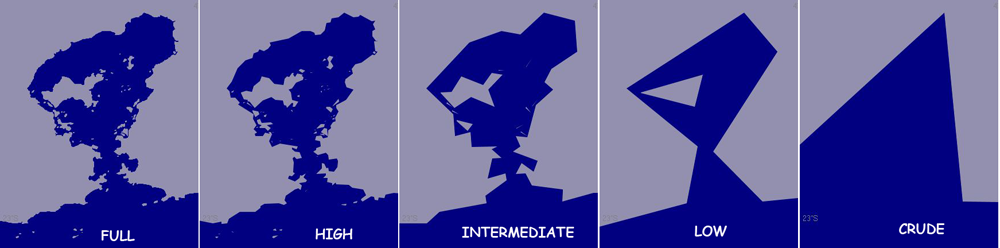
| + | The following image illustrates the level of detail of each file (Guanabara bay - 20 NM across) [img http://www.tecepe.com.br/nav/gshhs/gshhsResolutions.png] | ||
| + | |||
| + | == Pixel charts == | ||
| + | Charts with collision detection ''pixels'' from [http://gwranking.forumactif.org/ '''GWRanking'''] | ||
== Wind forecasts == | == Wind forecasts == | ||
| − | + | Wind forecasts can be obtained from a number of sources. Ultimately, most wind forecasts come from the GFS | |
| + | ( Global Forecast System, a world weather model run by [http://www.noaa.gov '''NOAA.'''] | ||
| + | |||
| + | VRTool can use winds from: | ||
* Downloaded directly from the NOAA server using the vrtool's built-in [[Importing NOAA Winds|NOAA import module]]. This method gives the earliest possible forecast updates, as the NOAA server is also the source for the other methods. This is also the most convenient way to import a grib covering the whole area of a race leg. Once the grib boundaries have been set in the [[Importing NOAA Winds|NOAA import module]], vrtool remembers them for subesquent imports. This makes subsequent updating of the wind grid a one-click process. | * Downloaded directly from the NOAA server using the vrtool's built-in [[Importing NOAA Winds|NOAA import module]]. This method gives the earliest possible forecast updates, as the NOAA server is also the source for the other methods. This is also the most convenient way to import a grib covering the whole area of a race leg. Once the grib boundaries have been set in the [[Importing NOAA Winds|NOAA import module]], vrtool remembers them for subesquent imports. This makes subsequent updating of the wind grid a one-click process. | ||
| − | + | * Load a GRIB2 file ( p.e. files downloaded by UGrib or ZyGrib). You can use either .grb or .grb.bz2 (compressed grib 2). | |
| − | * Load a GRIB2 | + | * If you use the Firefox browser you can extract Virtual Regatta game winds from the browser cache using the Firefox cache importer built into VRTool. (This "back-door" method depends on both the game file format and the browser cache management - it may stop working unexpectedly if either of these changes). Read more about this method in this [http://www.tecepe.com.br/NAV/VRTool/offline/TutorialFCI.htm tutorial]. |
| − | * | ||
| − | |||
| − | |||
| − | |||
| − | |||
| − | |||
| − | |||
| − | |||
| − | After loading the | + | After loading the winds you may use number buttons to select a given forecast. |
| + | Use buttons Ctrl-1 to Ctrl-7 or the buttons in the toolbar to display successive wind forecast periods. | ||
== Polars == | == Polars == | ||
| Line 35: | Line 59: | ||
* Multi-sail polars - This is a new format with a set of polar data for each sail. This is the preferred format. Multi-sail polar database files have extension XML, and can be produced, imported and edited using the vrtool polar studio. | * Multi-sail polars - This is a new format with a set of polar data for each sail. This is the preferred format. Multi-sail polar database files have extension XML, and can be produced, imported and edited using the vrtool polar studio. | ||
| − | * Merged sail polars - | + | * Merged sail polars - Compact polar database format. Extension .CSV. |
| + | Files available in the website [http://gwranking.forumactif.org/ gwranking] | ||
| + | |||
| + | Select the file and click load. | ||
| + | |||
| + | Also select which database type you are using in the '''Winds > Polars''' tab | ||
| + | |||
| + | (xml, csv or myPolars) | ||
| + | |||
| + | == Boat data == | ||
| + | VRTool has advanced features that can import boat data from the following sources, and use it to plot tracks on the chart: | ||
| − | + | * VRTool's [[File:ToolbarGPS.gif]] '''GPS module''' contains a TCP/IP client that can read an NMEA data stream from on an on-board wired or wireless TCP/IP network. VRTool can plot the position of your boat (using NMEA GPS messages) and nearby boats (using AIS messages). | |
| + | * The same facility can read '''game''' data streamed as NMEA messages over the internet via a TCP/IP proxy server. Your friends boats can also be plotted if the proxy serves these as NMEA AIS messages. | ||
| + | * From an on-board NMEA network through a hard-wired COM port. | ||
| + | * From NMEA messages in a text file. | ||
| + | * For Virtual Regatta games: VRTool can be configured to poll the game server directly to retrieve the position, course and speed of your boat and your friends. | ||
| + | * For Virtual Regatta games: VRTool can recover boat positions (and game weather) from the Firefox browser cache, provided you are running the game console in Firefox (obsolete). | ||
| − | + | Detailed instructions for each of these methods are [[Importing Boat Data|here]]. | |
| − | |||
| − | |||
Latest revision as of 09:21, 8 April 2015
VRtool needs data to perform calculations. Those have to be loaded in the program before you can use the track designer or the weather routing module, for example. These data files are charts, wind forecasts and polars. All VRTool data files are in text format, to allow easy editing and repairing files.
Vector charts
VRTool uses a custom vector chart format, in ASCII text, with extension .CHT. The program comes with a simple world map (world3.cht).
To load a vector chart, use menu option File > Open Vector Chart... Multiple charts can be open at the same time, by using File > Merge Vector Chart...
GSHHS charts
A detailed set of charts covering the whole planet is the GSHHS database (Global Self-consistent, Hierarchical, High-resolution Shoreline Database [1])
Version 2.3.4 of the database was released Jan. 1, 2015.
Translation of the GSHHS files to CHT format are available for download below.
Includes lakes, islands in lakes, antarctic ice front and ground line. Files are zipped.
- Full resolution data ( 60 MB )
- High resolution data ( 14 MB )
- Intermediate resolution data ( 3.5 MB ) <-- recommended
- Low resolution data ( 757 KB )
- Crude resolution data ( 112 KB )
From crude to full resolution, each file has 4 times as many points and polygons as the previous. Full resolution has 188.570 polygons and 10.922.276 points. Intermediate and High quality are OK for virtual regattas. Full resolution is probably too much for most computers. Download, save and unzip to VRTool program folder (p.e. c:\program files (x86)\VRTool).
Note that these charts are NOT intended to be used for real NAVIGATION. Use at your own risk.
Thanks Mr David Taylor for posting the Mapping Tools, used in the conversion [2]
The following image illustrates the level of detail of each file (Guanabara bay - 20 NM across) [img http://www.tecepe.com.br/nav/gshhs/gshhsResolutions.png]
Pixel charts
Charts with collision detection pixels from GWRanking
Wind forecasts
Wind forecasts can be obtained from a number of sources. Ultimately, most wind forecasts come from the GFS ( Global Forecast System, a world weather model run by NOAA.
VRTool can use winds from:
- Downloaded directly from the NOAA server using the vrtool's built-in NOAA import module. This method gives the earliest possible forecast updates, as the NOAA server is also the source for the other methods. This is also the most convenient way to import a grib covering the whole area of a race leg. Once the grib boundaries have been set in the NOAA import module, vrtool remembers them for subesquent imports. This makes subsequent updating of the wind grid a one-click process.
- Load a GRIB2 file ( p.e. files downloaded by UGrib or ZyGrib). You can use either .grb or .grb.bz2 (compressed grib 2).
- If you use the Firefox browser you can extract Virtual Regatta game winds from the browser cache using the Firefox cache importer built into VRTool. (This "back-door" method depends on both the game file format and the browser cache management - it may stop working unexpectedly if either of these changes). Read more about this method in this tutorial.
After loading the winds you may use number buttons to select a given forecast. Use buttons Ctrl-1 to Ctrl-7 or the buttons in the toolbar to display successive wind forecast periods.
Polars
Polars allow the calculation of the boat speed for a given wind speed and wind angle.
Vrtool can use two kinds of polar chart databases.
- Multi-sail polars - This is a new format with a set of polar data for each sail. This is the preferred format. Multi-sail polar database files have extension XML, and can be produced, imported and edited using the vrtool polar studio.
- Merged sail polars - Compact polar database format. Extension .CSV.
Files available in the website gwranking
Select the file and click load.
Also select which database type you are using in the Winds > Polars tab
(xml, csv or myPolars)
Boat data
VRTool has advanced features that can import boat data from the following sources, and use it to plot tracks on the chart:
- VRTool's
 GPS module contains a TCP/IP client that can read an NMEA data stream from on an on-board wired or wireless TCP/IP network. VRTool can plot the position of your boat (using NMEA GPS messages) and nearby boats (using AIS messages).
 - The same facility can read game data streamed as NMEA messages over the internet via a TCP/IP proxy server. Your friends boats can also be plotted if the proxy serves these as NMEA AIS messages.
- From an on-board NMEA network through a hard-wired COM port.
- From NMEA messages in a text file.
- For Virtual Regatta games: VRTool can be configured to poll the game server directly to retrieve the position, course and speed of your boat and your friends.
- For Virtual Regatta games: VRTool can recover boat positions (and game weather) from the Firefox browser cache, provided you are running the game console in Firefox (obsolete).
Detailed instructions for each of these methods are here.