version 2.31

VRTool software support forum

version 2.31

Postby omar » Mon Oct 13, 2014 6:39 pm

I posted version 2.31. Corrected two problems:
1- Negative TWA in the game broke some functionality. Converted to absolute value.
2- Course did not show when using auto TWA. Fixed.

Use installer to update
User avatar
omar
Site Admin
 
Posts: 498
Joined: Thu Apr 30, 2009 11:00 am

Re: version 2.31

Postby FS Neroform 100 » Tue Oct 14, 2014 3:25 pm

thanks a lot Omar - now my problems are solved ............... great !
Ueli
FS Neroform 100
 
Posts: 32
Joined: Thu Apr 22, 2010 12:14 pm

Re: version 2.31

Postby eotamis » Wed Oct 15, 2014 8:41 am

Hi Omar, thanks for the update, seems to work fine except one thing I've come across a few bugs (don't know if that's specific to my hardware) an obstacle within the Weather Routing subroutine;

- when the land collision window is opened via button though weather routing config tab, "load BMP" command just does not respond/work (seems that the installer has the appropriate mono bmp file in the install directory)
- when the build track tree command is executed with the land collision detection check box checked, null is returned with a debugger report showing just below the executed command button saying "Not pf1 bit (C:\dspr32\NAV\vrtool\LandCollisionDetector.pas, line 58) "

do you think it's me or last version will need a fix?

thanks in advance
regards
eotamis
 
Posts: 4
Joined: Wed Oct 15, 2014 8:18 am

Re: version 2.31

Postby omar » Sun Oct 19, 2014 7:36 pm

The land collision bitmap is a fairly large image used by
the collision engine. Since the program keeps it in memory,
it is required to be in a 1-bit-per-pixel BMP image mode.

The file monoBmpGSHHS_24k12k.bmp is a 24k x 12k pixels BMP
for the whole world that ships with the program (default).

If you want to make your own bitmap, make sure it is saved as a mono BMP.
Note that VRTool itself can generate this BMP from a vector chart.
User avatar
omar
Site Admin
 
Posts: 498
Joined: Thu Apr 30, 2009 11:00 am

Re: version 2.31

Postby eotamis » Mon Oct 20, 2014 12:03 am

thanks a lot, now I can open the vector chart generated bmp's in collision detector subroutine.
though I'd like to give one more feedback about the monochrome bitmap generator as top,left and bottom,right point designations seem to be misleading
i.e. for an area defined between latitudes of 13N and 17N and longitudes of 27W to 21W one has to enter 13 and 27 in top/left entries and 17,27 for bottom/right entries to get the area right
just fyi

thanks again for your kind response
eotamis
 
Posts: 4
Joined: Wed Oct 15, 2014 8:18 am

Re: version 2.31

Postby omar » Mon Oct 20, 2014 11:55 am

eotamis wrote:as top,left and bottom,right point designations seem to be misleading

Hum.. you are right. :mrgreen:
Thanks
User avatar
omar
Site Admin
 
Posts: 498
Joined: Thu Apr 30, 2009 11:00 am

Re: version 2.31

Postby omar » Thu Oct 23, 2014 11:15 am

WR 
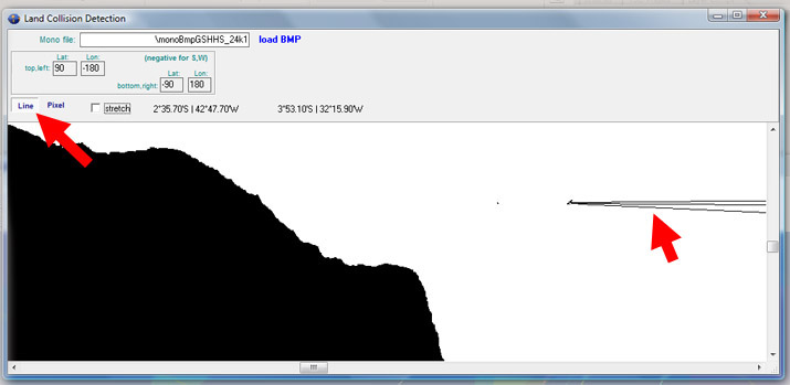
tip: If you want to set the weather routing Destination further ahead of the next mark
but want to avoid passing in the wrong side of it, open collision detection module and
use the [line] tool to draw a couple lines as shown below (in this case to Fernando de Noronha's port side).
Click the two end-points to draw a line segment. WR Tracks will not cross these lines.

Note that the line is not added to the actual bitmap file
(i.e. it stays only until the program is terminated).
If you want to add a persistent line to your collision detection bitmap,
use a drawing software like Photoshop or Paint.

Remember to keep the 1-bit-per-pixel BMP format. :!:

Image

now something different
Image
User avatar
omar
Site Admin
 
Posts: 498
Joined: Thu Apr 30, 2009 11:00 am

Re: version 2.31

Postby eotamis » Fri Oct 24, 2014 3:43 pm

:) Brilliant laylines!! it works!
let me also mention that they're gone when the bmp is reloaded as well.
and instead of a photoshop/paint one can also consider permanent laylines by adding visible tracks/routes to the vector chart from which a bmp may be created within the program as well
thanx much for your thorough guidance!!
regards
eo
eotamis
 
Posts: 4
Joined: Wed Oct 15, 2014 8:18 am

Re: version 2.31

Postby hugovk1 » Sun Nov 09, 2014 1:40 am

Hi Omar, I have exactly the same issue that eotamis raised Oct 15 re Land Collision Detector but can't understand how he resolved the problem.

I can't load either the monoBmpGSHHS_24k12k.bmp file nor my own BMP file generated using VRTool.

The "Load BMP"command does not do anything - nor does entering the file address of BMP file.

Are you able to assist with any further explanation. Many thanks. (trying to get better organized for VOR leg 2 :? )
hugovk1
 
Posts: 3
Joined: Mon Oct 13, 2014 6:55 am


Return to VRTool Forum